
Magburaka
| Magburaka | |||
|---|---|---|---|
|
|||
| Coordinates | 8 ° 43 ′ N , 11 ° 57 ′ W | ||
 Map of Tonkolili District Map of Tonkolili District
|
|||
| Basic data | |||
| Country | Sierra Leone | ||
| Northern Province | |||
| District | Tonkolili | ||
| ISO 3166-2 | SL-N | ||
| Chiefdom | Kholifa Rowalla | ||
| Residents | 11,006 (1985) | ||

Magburaka is a city in Sierra Leone . It is the capital of the Tonkolili district and is located in the Northern Province . The place is located on the Rokel River and is the intersection of the roads from Freetown to Kabala and Makeni to Koidu . The city is located in the center of Sierra Leone.
The population belongs to the Temne people . The population grew from 1963 6371 to 1974 10,347 to 1985 11,006 people. Estimates today assume around 15,000 inhabitants.
The city is a trading center for cola nuts, palm oil , rice and tomatoes.
In addition to the usual administrative buildings of a district capital, there is a hospital and a teachers' seminar.
gallery

Downtown Magburaka
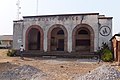
Post office in Magburaka

