Mago National Park
| Mago National Park | ||
|---|---|---|
| Mago National Park, February 2006 | ||
|
|
||
| Location: | Region of the Southern Nations, Nationalities and Peoples , Ethiopia | |
| Surface: | 5061 km² | |
| Founding: | 1971 | |
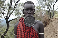
| Mursi woman | ||
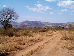
The Mago National Park is located 770 kilometers south-west of Addis Ababa in the area Gam Gofa in Ethiopia . It was founded in 1971 and serves to protect large mammals such as giraffes , buffalo and elephants . Its size is 2162 km², it lies at an altitude of 450 to 2528 meters, the highest point is Mount Mago . It is traversed by the Mago River of the same name .
The park is characterized by a savannah landscape. The Mursi people live in the Mago National Park .
Mursi
The Mursi are an ethnic group that lives in southern Ethiopia, more precisely in the Mago National Park. The tribe are less associated than 4,000 people mainly from livestock and farming life. The Mursi are increasingly improving their income by acting as "photo objects" for tourists. Characteristic of this tribe is the eye-catching lower lip decoration of the women, which consists of a large clay plate (up to 15 cm in diameter). A painted body and self-added decorative scars are also considered beauty features. The tribe uses the Mursi language of the same name .


