Maja e Meqithit
| Maja e Meqithit | ||
|---|---|---|
|
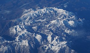
Cukali mountains from the east with Maja e Meqithit to the right of the white field Fusha e Liqenit |
||
| height | 1734 m | |
| location | Albania | |
| Mountains | Albanian Alps | |
| Dominance | 14.6 km → Maja e Bishkazit | |
| Notch height | 744 m ↓ Qafa e Çisës | |
| Coordinates | 42 ° 9 '12 " N , 19 ° 45' 22" E | |
|
|
||
| rock | lime | |
|
Summit region with the Maja e Muleqithit to the right of the white Fusha e Liqenit |
||
The Maja e Muleqithit is the highest peak in the Cukali highlands in northern Albania . The 1721 m above sea level. A. high mountain lies east of Shkodra . About two kilometers further south-west rises the only slightly lower Maja e Cukalit ( 1721 m above sea level ).
The Maja e Muleqithit is a small pyramid, placed on the slightly less steep summit area of the Cukali massif . The summit drops steeply to the northwest into the deeply cut valley of the Kir . In the northeast lies the deeply cut valley of the Shala . Towards the south and east towards the Drin , the landscape is not quite as steep.
A forest path leads on the southern flank up to 1500 m above sea level. A. up the mountain. The road previously circled the Maja e Cukalit and passed the flat field Fusha e Liqenit on the south side of the mountain, on the other side of which the Maja e Cukalit rises.


