Makgadikgadi salt pans
Coordinates: 20 ° 49 ′ 0 ″ S , 25 ° 25 ′ 0 ″ E
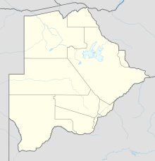
The Makgadikgadi salt pans [ maˈkxadiˈkxadi ] (English: Makgadikgadi Pans ) are a collection of individual salt pans in northeastern Botswana . According to a scientific study by the University of Sydney , this is the birthplace of Homo sapiens sapiens .
geography
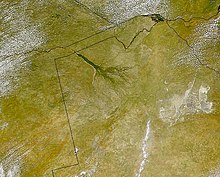
The Makgadikgadi pans consist of a large number of larger and smaller salt pans, which are located in the northeastern area of the Kalahari, southeast of the Okavango Delta . With an extension of more than 8,400 km², they are considered to be one of the largest salt pans on earth , after the Salar de Uyuni in Bolivia and the Great Salt Desert in Utah, USA. The most important tributaries are the Nata (from the confluence of Maitengwe and Manzamnyama) into the Sowa pan and the Boteti , which comes from the Okavango Delta and seasonally feeds the Ntwetwe pan .
Emergence
At the site of today's Makgadikgadi salt pans there used to be a large lake ( Makgadikgadisee ). It covered an average of about 60,000 km² and reached a depth of up to 30 meters. Since the lake was without a drain, the salt concentrated. Due to climate change and earth movements around 4,000 years ago, the lake dried up and left salt crusts up to five meters deep at its deepest points, today's salt pans.
landscape
The Makgadikgadi Salt Pans are the most sparsely populated region of Botswana. The pans are without vegetation, on their edges there is flat grassland. By far the largest pans are the Ntwetwe pan and the Sowa pan. Because of the Mopipi dam , which supplies the diamond mine in Orapa with water, the Boteti, the tributary to the Ntwetwe pan, only rarely carries water into the pan today. Therefore it is almost always dry. The sowa pan is fed by the nata. During the rainy season, a large lake is usually formed in the northern part, which attracts many birds, including pelicans , flamingos , herons and storks .
Flora and fauna
The salt pans themselves are pure salt deserts that are surrounded by grass savannah . North and west of the Ntwetwe pan also grow doum palms (Hyphaene) and the islands in particular - such as Kubu Island and Gabasedi Island - are made up of baobab ( baobab ), some of which have become popular with tourists, such as Bain's Baobabs or Chapman's Baobab .
While in the dry season only a few animal species, especially birds such as ostriches , plover plovers , shepherd's plovers , various turtles and lizards, such as white-throated monitor lizards or the endemic Makgadikgadi spiny dragon (Agama hispida makgadikgadiensis) can survive in the hot and dry climate during the day In the midsummer rainy season from March to December the game from Chobe and Linyanti as well as from the Okavango Delta on the open grassy areas. At the time, game was concentrated in the northern areas from the Nxai pan in the west to the Sowa pan in the east.
Especially grazers such as gemsbok , springbok , impala , wildebeest and plains zebra migrate regularly to the Makgadikgadi Pans. Cape buffalo and elephant, on the other hand, only move to these regions during very humid years. The prey is followed by hunters such as lion , leopard , cheetah , caracal , hyena , African wild dog and jackal .
Where the salt pans are flooded in wet years and form huge lakes, the salt desert is transformed into a habitat for water birds such as ducks, geese and the great white pelican . During these years the salt pans are also home and breeding ground for thousands of flamingos .
At the end of the rainy season (around May), the game migrates further south to the Makgadikgadi plains on the grass savannahs on the edge of the Ntwetwe pan. When the smaller pans begin to dry out at the end of the rainy season, the game moves to the Boteti and migrates up to the Okavango Delta and then partly further northeast to Linyanti and Chobe.
economy
The company Botswana Ash (Botash), which mines sodium carbonate and salt in the middle of the Sowa pan , and the largest diamond mines in the world at Orapa are of economic importance . Located south of the Ntwetwe salt pan, they consume a large part of the water carried here by the Boteti from the Okavango delta and thus pose a problem for the natural balance and the water balance of the region. In addition, tourism plays an outstanding role for the entire Central Kalahari .
tourism
On the western edge of the salt pans are the Makgadikgadi Pans and the Nxai Pan National Park , both only separated by a road. The occurrence of wild animals in both pans is highly dependent on the season. To the north of the Sowa Pan is the Nata Bird Sanctuary , which includes a small, regularly flooded section of the salt pan and adjacent grassland. Here you will find the best opportunities for bird watching after a prolific rainy season. In the southwest of the Sowa pan is Kubu Island , a small elevation on the pan, where remains of earlier settlement can be found.
Catchment area
The Makgadikgadi Salt Pans are the deepest point of a hydrological basin in the northern Kalahari Basin . The total catchment area of the endorheic basin is 721,258 km² and is mostly in an arid desert climate. The main part of the catchment area with 413,550 km² belongs hydrologically to the Okavango, which rises in the Angolan highlands. However, this also includes dry river beds such as the Eiseb and the Omatako , which only has water in the upper reaches, and the areas up to the Cuando , in which there is an interaction with the Zambezi catchment area. The part of the area that actually drains is only 171,000 km² (plus 15,844 km² delta).
Since most of the catchment area is in areas with 300 to 500 mm of precipitation per year, the remaining 300,000 km² hardly contribute any water to the basin. Significant quantities only come from the Nata coming from Zimbabwe , which has a catchment area of just over 20,000 km². The rest belongs to the Okwa coming from the Kalahari and the Deception pan with 164,543 km² or the other pans.
The Makgadikgadi Basin extends over four countries. Most of it with almost half is in Botswana. The rest, apart from a small part in Zimbabwe, is shared almost equally by Angola and Namibia. The Makgadikgadi catchment area is divided as follows:
| States | Catchment area of the state in [km²] | Percent of the area of the catchment area | Percent of the country's area |
|---|---|---|---|
| Botswana | 338.270 | 46.9 | 58.1 |
| Angola | 199,067 | 27.6 | 16.0 |
| Namibia | 163,726 | 22.7 | 19.9 |
| Zimbabwe | 20.195 | 2.8 | 5.2 |
| total | 721.258 | 100 |
literature
- Michael Iwanowski: Deserts, swamps and savannahs, travel guide Botswana. Iwanowski Reisebuchverlag, Dormagen 1992, ISBN 3-923975-04-X .
Individual evidence
- ↑ discussion in the newsgroup sci.lang on 19 April 2005
- ↑ The exact birthplace of modern humans is determined on the website orf.at , accessed on October 29, 2019
- ↑ BAILLIEUL, Thomas A. Makgadikgadi Pans complex of central Botswana: summary. Geological Society of America Bulletin, 1979, Vol. 90, No. 2, pp. 133-136.
- ↑ a b c An overview of key strategic issues in the Okavango basin
- ^ Okavango Basin - Hydrology
- ^ Groundwater recharge in the Kalahari, with reference topaleo-hydrologic conditions
Web links
- C. Michael Hogan: Makgadikgadi . In: The Megalithic Portal and Megalith Map . Retrieved September 29, 2013.


