Malý Háj
| Malý Háj | ||||
|---|---|---|---|---|
|
||||
| Basic data | ||||
| State : |
|
|||
| Region : | Ústecký kraj | |||
| District : | Must | |||
| Municipality : | Hora Svaté Kateřiny | |||
| Geographic location : | 50 ° 35 ′ N , 13 ° 25 ′ E | |||
| Residents : | 9 (2011) | |||
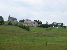
Malý Háj ( German Kleinhan ) is a district of Hora Svaté Kateřiny in Okres Most in the Czech Republic . The place arose as a Waldhufendorf , whose name probably developed from Kleiner Hain and describes its location in the middle of the forest with few houses.
history
It was first mentioned in writing in 1549. At that time the village belonged to Rothenhaus . The first settlers probably came from Westphalia and were invited by the gentlemen on Rothenhaus. Each settler was given a part of the forest that he was supposed to clear; the resulting field would later belong to him. During the Thirty Years War , the Swedes had to stop in the town because of a typhus epidemic . The Schwedenweg ( Švédská cesta ) and the Schwedenfriedhof ( Švédský hřbitov ) remind of this event .
In 1846 two boys found a pot of silver coins, the so-called Swedish treasure, below the Steindl (Kamenný vrch) , where they were herding cattle. In the 19th and early 20th centuries, most of the residents made a living from forestry. Most of the wood produced was exported to Saxony .
In 1953, Malý Háj, which belonged to Rudelsdorf before the Second World War , became part of Hora Svaté Kateřiny.
Development of the population
|
|
|
Attractions
The widely visible Church of the Holy Trinity ( Nejsvětější Trojice ), built in 1783, was originally a branch church of Katharinaberg, but was made a locality in 1791 and a parish in 1852. She stands on a hill. The church has been renovated since 1993 with the support of the Deutschneudorf parish.
The Eduardova skála (Eduardfelsen), off the beaten track, is around 900 meters high in the middle of a small forest. From the top there is a view of the Ore Mountains and the town of Hora Svaté Kateřiny.
Web links
- Kleinhan / Rudelsdorf and cargo on boehmisches-erzgebirge.cz
Individual evidence
- ↑ a b Historický lexikon obcí České republiky - 1869-2015. Český statistický úřad, December 18, 2015, accessed on January 18, 2016 (Czech).


