Manhartsberg
| Manhartsberg | ||
|---|---|---|
|
Manhartsberg east of the Kamp |
||
| height | 537 m above sea level A. | |
| location | Lower Austria | |
| Mountains | Bohemian mass | |
| Dominance | 11.8 km → Brenntenberg | |
| Notch height | 131 m ↓ Stockern (municipality of Horn ) | |
| Coordinates | 48 ° 32 '38 " N , 15 ° 44' 56" E | |
|
|
||
The Manhartsberg is a low, flat mountain ridge in Lower Austria . Its height is 537 m above sea level. A. It is the south and east flank of the granite massif of the granite and gneiss plateau , the Austrian part of the Bohemian mass .
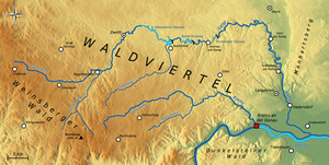
The ridge extends from the Thaya to the Wagram and is partially covered with tertiary layers (sands). This ridge continues in the Moravian region to the Znojmo region. As the eastern edge of the Bohemian massif, the Manhartsberg forms the "boundary stone" for the quarter above the Manhartsberg ( Waldviertel ) and the quarter below the Manhartsberg ( Weinviertel ). Its west side was formed by the camp . The western slopes of Manhartsberg are part of the Kamptal-Schönberg Nature Park .
Above Maissau there are rich amethyst deposits .
Near its highest point there are still some remains of a radio interference from the Second World War with the code name Zangendorf 4 .
The state road 1238 leads over the Manhartsberg, but it is a dirt road in the area of the Manhartsberg.
The Manhartsberg is considered the border between Waldviertel and Weinviertel . The dean's office of the Archdiocese of Vienna , which corresponds to Weinviertel , is still called "under the Manhartsberg" today.

