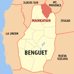
Mankayan
| Mankayan Township | ||
| Location of Mankayan in the Benguet Province | ||
|---|---|---|

|
||
| Basic data | ||
| Region : | Cordillera administrative region | |
| Province : | Benguet | |
| Barangays : | 12 | |
| District: | 2. District of Benguet | |
| PSGC : | 141111000 | |
| Income class : | 3rd income bracket | |
| Households : | 6495 May 1, 2000 census
|
|
| Population : | 35,953 August 1, 2015 census
|
|
| Population density : | 205.3 inhabitants per km² | |
| Area : | 175.14 km² | |
| Coordinates : | 16 ° 52 ' N , 120 ° 47' E | |
| Postal code : | 2608 | |
| Area code : | +63 74 | |
| Mayor : | Manalo galutes | |
| Geographical location in the Philippines | ||
|
|
||
Mankayan is a Filipino municipality in the Benguet Province . It has 35,953 inhabitants (August 1, 2015 census). In the municipality is the 2,187 meter high Mount Data , on the mountain slopes of which are the sources of the rivers Abra , Agno and Chico . Parts of Mount Data National Park are in the municipality's territory.
Barangays
Mankayan is politically divided into twelve barangays .
- Balili
- Bedbed
- Bulalacao
- Cabites
- Colalo
- Guinaoang
- Paco
- Palasaan
- Poblacion
- Sapid
- Tabio
- Taneg
Sons and daughters
- Joseph Amangi Nacua OFMCap (* 1945), Roman Catholic religious, retired Bishop of Ilagan
