Manuherikia River
| Manuherikia River | ||
|
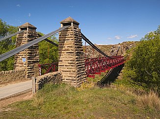
Daniel O'Connell Bridge, suspension bridge over the Manuherikia River near Ophir |
||
| Data | ||
| location | Otago , New Zealand | |
| River system | Clutha River | |
| Drain over | Clutha River → South Pacific | |
| source | Maniototo Plain | |
| Source height | 280 m | |
| muzzle |
Alexandra coordinates: 45 ° 15 ′ 35 ″ S , 169 ° 23 ′ 37 ″ E 45 ° 15 ′ 35 ″ S , 169 ° 23 ′ 37 ″ E
|
|
| length | 85 km | |
| Left tributaries | Thomson's Creek | |
| Right tributaries | Dunstan Creek, Lauder Creek, Cemetery Creek | |
| Big cities | - | |
| Medium-sized cities | Alexandra | |
| Small towns | Blackstone Hill , Becks , Lauder , Omakau , Ophir , Springvale , Galloway | |
The manuherikia river is a river in the region Otago on the South Island of New Zealand .
geography
The river has its source in the north of the Maniototo Plain , then flows 85 kilometers to the southwest, to finally unite with the Clutha River at Alexandra . In the 1860s, the Manuherikia was one of the centers of the gold rush in Otago . The State Highway 85 approximately follows the course of the river. Likewise, the railway line of the Otago Central Railway followed the lower and middle reaches.
history
The Shaky Bridge suspension bridge in Alexandra, now a pedestrian bridge, was inaugurated in 1879 to avoid the risky crossing of the river with horse and cart on a boat during floods. The bridge cost 974 pounds. It was later sold to two settlers for the symbolic price of £ 1. The bridge then fell into disrepair. Since the connection was needed, $ 1,800 was raised for a repair. During the repair work, the bridge was narrowed and only intended for pedestrians. Another suspension bridge, the Daniel O'Connell Bridge , is at Ophir .
The Manuherikia River is home to one of New Zealand's largest fossil sites, the St. Bathans Fauna .
