Matmata
| Matmata |
||
|---|---|---|
| Matmata - caves and structures above ground | ||
| administration | ||
| Country |
|
|
| Governorate | There was | |
| Post Code | 6070 | |
| Demographics | ||
| population | 2116 pop (2004) | |
| geography | ||
| height | 600 m | |
|
|
||
| Coordinates | 33 ° 33 ' N , 9 ° 58' E | |
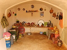
Matmata ( Arabic مطماطة, DMG Maṭmāṭa , Central Atlas Tamazight ⵎⴰⵟⵎⴰⵟⴰ Maṭmaṭa ) is a Berber town with around 2,500 inhabitants in southern Tunisia . He is known for several cave dwellings.
location
Matmata lies at an altitude of approx. 600 m above sea level. d. M. in the north of the Djebel-Dahar mountain country. The place is about 440 km (driving distance) in a southerly direction from Tunis ; the next largest city Medenine is about 80 km to the east.
history
Oral tradition reports that in Roman times, eastern tribes settled in the Matmata region, from which the local Berber population hid in crevices and pits. The men worked in the olive groves of the north and were also rewarded with olive oil . They exchanged this for goods and food.
Until the 16th or 17th century, when today's population built the cave dwellings, there was a fortress, the remains of which can still be seen. The houses located there were given up in favor of the underground apartments, which save materials and costs and compensate for temperature fluctuations.
Contrary to the legends that are rumored about the forgotten Berber village, it was also known in the 19th century. In 1897, for example, Petermanns Geographische Mitteilungen report on the "cave village".
Uprisings (from 1915)
Insurgents led by Mohamed Daghbaji (1915–1921), who was arrested by Italians in Libya, extradited and executed in 1924, found refuge here. Daghbaji deserted from the colonial army in 1915 and became one of the first to use force to defend himself against French rule. At the same time, the Ouderna rose against the French and, in Libya, other Berber groups against the Italian colonization. The Ouderna tried to restore Ottoman suzerainty, but were defeated by 30,000 French soldiers. The Libyan groups held out in Italy until the end of fascism; some Ouderna fled to them and supported them.
Second World War
During the Second World War , when Gabès was occupied by German troops and was shot at, the Berbers Matmatas took in refugees. In the direction of Gabès, two bunkers were built in 1936 (5 km from Gabès). They were part of the Mareth Line that France had built against Italian Libya from 1936 to 1939.
New matmata
The French colonial government was just as unaware of the settlements as its predecessors. In 1959, the Tunisian government began building Nouvelle Matmata, a modern settlement. Some families moved there from 1962 onwards, but it was mainly young families who saw hardly any accommodation in the old settlement, who left their familiar surroundings and moved 15 km towards Gabès. Those who had a house in the old city stayed there. In 1967, however, after heavy rains that lasted 22 days, some of the buildings collapsed, so the residents asked government agencies in Gabès for support. The residents rebuilt their usual buildings that were appropriate for the desert climate, and where possible equipped them with newer technology.
architecture
The design principles of the apartments are at least 400 years old. First, about 7 m deep pits with a diameter of about 10 m were dug into the soft sandstone, so that a central square was created. Rooms and apartments were dug into the resulting vertical walls at ground level. A little higher in the wall, there were also small chambers for supplies or hollows that served as cisterns. Steps led to them. Some had holes in the ceiling through which grain could be poured. A narrow path, which the domestic animals could use, led down from the plain into the pit. Sometimes the large pit was dug into a hill so that the apartments could be reached sideways, i.e. on a horizontal path. The construction time was six to twelve months, depending on the size and requirements.
tourism
Today the place is often visited by tourists, but this is controversial in the place; therefore tourists are only allowed to walk through the village with a guide. Some tourists broke into the houses with their cameras, so that fences have now been drawn and dogs guard the apartments. Around half of the original 700 rooms and apartments are still inhabited today. A total of around 5,000 people live in earth houses in the region.
See also
- The cave dwellings of Matmata are part of the Berber architecture , the many original architectural solutions has produced. Also in Morocco (e.g. in Bhalil near Sefrou ) there are a number of cave dwellings - driven into vertical rock walls.
- The Hotel Sidi Driss in Matmata was used in 1976 as the location for the first part of Star Wars ("Episode IV").
literature
- Ernst von Hesse-Wartegg: Saharan cities under the earth , in: Reclams Universum 26 (1910) 104-109
Web links
- The Real Star Wars? ( Memento of June 25, 2008 on the Internet Archive ) Associated Press January 25, 2006 (English)
Remarks
- ↑ Recensement de 2004 Institut national de la statistique ( Memento of the original of September 24, 2015 in the Internet Archive ) Info: The archive link was inserted automatically and has not yet been checked. Please check the original and archive link according to the instructions and then remove this notice.
- ^ Petermanns Geographische Mitteilungen, 43 (1897) 110.
- ^ Daniel Jacobs, Peter Morris: Jedi Stomping Ground. Tunisia , 6th ed., Rough Guides, London 2001, p. 319.


