Djebel Dahar
| Djebel Dahar | ||
|---|---|---|
|
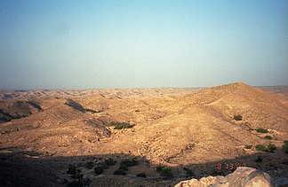
Mountains near Matmata |
||
| Highest peak | Djebel Zemertène ( 713 m ) | |
| location | Tunisia | |
|
|
||
| Coordinates | 33 ° 24 ' N , 10 ° 8' E | |
| rock | limestone | |
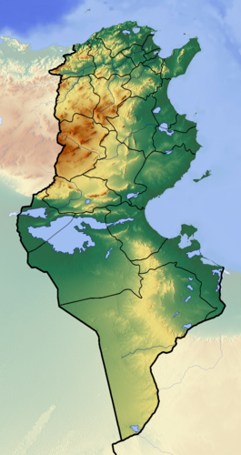
The mountains of the Djebel Dahar (also Jebel Dahar ; Arabic جبال الظاهر, DMG Ǧibāl aẓ-Ẓāhir ) is a maximum 713 m high mountain range in southern Tunisia .
Expansion and landscape
The Dahar extends from the Matmata region south and south-east over more than 100 kilometers to the area of Foum Tataouine . The foothills of the mountain range extend another 100 kilometers to the Libyan border, where it continues in the Jabal Nafusa .
In the northwest, the Dahar is bounded by the Djebel Tebaga , in the east by the fertile Djeffara plain, and in the south and west by the endless deserts or semi-deserts of the Sahara . Compared to the Tunisian dorsal and the foothills of the Atlas , the Dahar is relatively modest; only the Djebel Zemertène (713 m, approx. 30 km west of Medenine ) makes it to an altitude of over 700 m. However, the shapes of the mountains are all the more impressive: They are mostly steeply sloping table mountains , which are partly interrupted by narrow gorges, but partly also by wider valleys.
Vegetation and climate
Only very sparsely overgrown by half grass , thorn bushes and here and there a palm tree, the area gives the impression of a lunar landscape in many places. The climate is also suitable: dry, rough and often windy. While the nights in particular can get bitterly cold in winter (freezing temperatures are not uncommon), the Dahar turns into an oven in summer when daytime temperatures of up to 45 ° C prevail. Precipitation falls only to a very limited extent, on around 15 to 20 days a year, most likely in the winter half of the year and mostly in the form of heavy downpours - in some years the rain is completely absent.
Settlement and agriculture
The Dahar has been settled by various Berber tribes for thousands of years , who have adapted excellently to life in this barren mountainous country and have left their mark on the landscape. For example, one often finds fields laid out on slopes on terraces , which serve the optimal utilization of the sparse soil and rainwater. The terraces are built from earth and stone dams, the so-called Djessour , which also gave the fields their name: 'Djessourfelder'. Behind these dams, fruit and olive trees, vegetables and other plants are grown, which thrive with the moisture retained by the Djessour. Some typical, very well preserved and still cultivated terrace fields can be found in the region around Matmata.
In Roman times the Dahar was developed into an important rear line of the Limes Tripolitanus . The border installations of this defense and surveillance system, which had been advanced to the Sahara, consisted of several deeply staggered chains of forts and military posts, in addition there were military barriers that secured entire valleys with ramparts, walls and towers around the densely populated and economically important country east of the Dahar from attacks to protect from the desert regions and prevent illegal border crossings. In addition, the import and export of goods could be monitored and customs duties could be collected.
Home decor
The Dahar is known for special cave dwellings . There are basically two types of construction: horizontal cave dwellings and vertical funnel dwellings.
Funnel cavities

For funnel caves, a five to nine meter deep hole with a diameter of up to twelve meters is dug into the ground. As soon as this depression has been excavated, further holes are made from its base in all directions, this time horizontally. These are the future rooms that have no openings other than the door, which in turn usually only consists of a carpet curtain or remains entirely open. Occasionally there are even stick rooms that can be reached via steps cut into the wall and a climbing rope. Supplies are stored there and young couples traditionally spend the first week after the wedding . The sparse furnishing of the rooms is also carved into the walls, be it shelves, shelves, benches or the bed. At the end, the tunnel-like exit is dug from the inside to the outside, mostly in a winding shape and with niches for the cattle, and sloping slightly so that any rainwater can drain from the yard. Finally, there is a door to the outside, mostly decorated with traditional symbols such as the hand of Fatima or the fish and often hidden between the bushes and rocks. In the outside area of the resulting apartment there is sometimes a Berber tent and a shelter for the animals.
Although such cave dwellings have great advantages in terms of climate - they stay cool in summer and warm in winter - they are only partially compatible with modern living standards. Although some apartments are now supplied with running water and electricity, only a few families still live in their traditional dwellings. The majority, and especially the younger part of the population, give up the caves for newly built prefabricated buildings , in which they occasionally freeze in winter and need air conditioning in summer, but which offer electric kitchens, washing machines and other comforts. The traditional town of Matmata is gradually beginning to die out, while Nouvelle Matmata (New Matmata), 15 kilometers away, is becoming increasingly popular. In addition to the few troglodyte caves near Matmata itself, which are increasingly becoming a tourist attraction, there are also some in the towns of Beni Aïssa and Beni Métir (about 10 to 20 kilometers from Matmata).
It is controversial whether this interesting cave construction was used for defense or just a cheap and cool construction. Both assumptions are probably justified. The latter because of the climate and the former because it is known that from the 7th century the Berber tribes retreated to the barren mountains from wild Arab cavalry hordes (e.g. those of the pillaging Banū Hilāl from the Sahara) and from the threat of Arabization and Islamization .
Vertical troglodyte dwellings
The other type of cave dwelling is somewhat more common and widespread, but it is also increasingly being abandoned. For vertical cave dwellings, a hole is driven into a slope, the softer material being dug out to make room for rooms, and the harder layers being used as ceilings and floors. The design of the interior is similar to that of the funnel apartments. The resulting overburden is occasionally used for backfilling terraces or small walls. Dwellings obtained in this way were often built in the entire Dahar on ascending floors, with a storage and defensive castle at the highest point.
Storage castles
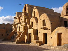
Another architectural form of the Dahar, like all of southern Tunisia, are the Ksour (plural of Ksar ), which - but in a different form - are also common in other parts of the Maghreb (see Agadir (Speicherburg) ). A ksar - the term is not clearly defined in Tunisia and is assigned to various buildings or building complexes, but especially to the Berber storage castles - consists of several basic units, the ghorfas . A ghorfa is a barrel-shaped arched structure in which - mostly on several floors - supplies, tools and other valuables were stored. Usually several such buildings are laid out with the doors leading inwards around a square courtyard, whereby their windowless outer walls also represent a defensive wall. Such a complex makes a ksar.
The semi-nomadic Berbers stored grain, oil and fodder here as well as their belongings when they went hiking with their sheep and goats. Most of the time, only a guard was left with his family, the elderly and small children. For optimal protection, such ksour in the Dahar were often created on dizzying rock ledges, but they can also be found further down in the plain, which suggests that they were created in more peaceful times. Not infrequently they also served as trading and resting places as well as storage rooms for passing caravans .
Most and most beautiful ksour can be found in the region around Tataouine . Comparable to the famous “Road of the Kasbahs ” in southern Morocco, there is the “Route of the Ksour” here in southern Tunisia. The most beautiful and best preserved ksar can be admired in Ouled Soltane (approx. 23 km southeast of Tataouine); there are others in Gattoufa , Ksar Ouled Debbab and Ksar Haddada (all within a radius of approx. 10 to 30 km from Tataouine). About 20 km south to north-west of Tataouine are the partly abandoned mountain villages of Douiret , Chenini and Guermessa . The city of Ghomrassen is also located in a basin of the Dahar.
tourism
In addition, the Dahar became internationally known as a film set. In 2000, the mountainous and subsequent desert landscape served as a backdrop for scenes from “The Rise of Empire”, just like the first Star Wars episode in 1977, which was filmed at Matmata. The locals let themselves be hired as dirt cheap extras.
The Dahar is becoming more and more popular with tourists because of its rugged landscape, which is particularly impressive in the light play of sunrise and sunset. Many visitors who are stationed on Djerba or in Zarzis book day trips to the Dahar, and trips to Tunisia usually include side trips to this mountainous region. However, the attractiveness also has a downside:
- " [...] now the cash register is made. When tourist buses arrive, some Berber families clear their house and leave grandpa in front of the door to collect the entrance fee. At every turn children pluck visitors by the sleeves to show their house, but there are no longer any free photos in Matmata. The atmosphere in the Berber village, where one was welcomed with great warmth a few years ago, is changing: you can now feel latent aggressiveness, which is only too understandable in view of the disrespectful hordes of tourists invading living and privacy ”.
This may be phrased in a somewhat drastic way, but at least it clearly describes the direction in which the situation is developing.
Web links
Individual evidence
- ↑ Michael Mackensen : forts and military posts of the late 2nd and 3rd centuries on the "Limes Tripolitanus" . In: Der Limes 2 (2010), pp. 20–24; here: p. 22.
- ^ David J. Mattingly : Tripolitania. Batsford, London 2005, ISBN 0-203-48101-1 , p. 188; Joëlle Napoli : Recherches sur les fortifications linéaires romaines (= Collection de École Française de Rome 229), École française de Rome, Rome 1997, ISBN 2-7283-0371-1 , p. 453. ( Dissertation , Paris 1988).
- ↑ Wolfgang Rössig: Bildatlas Special Tunisia. HB, Ostfildern 2002, p. 76


