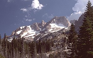
Matterhorn Peak (California)
| Matterhorn Peak | ||
|---|---|---|
|
View of the Matterhorn Peak |
||
| height | 3745 m | |
| location | California , United States | |
| Mountains | Sierra Nevada | |
| Dominance | 2.25 km → Twin Peaks | |
| Notch height | 476 m | |
| Coordinates | 38 ° 5 '35 " N , 119 ° 22' 54" W | |
|
|
||
| rock | granite | |
The Matterhorn Peak is a 3,745 m high mountain in the Sierra Nevada in the State of California of the United States . It lies on the border between Tuolumne County and Mono County .
Yosemite National Park stretches to the south and west, and the Hoover Wilderness to the northeast . The Burro Pass is about 1.1 km southwest . The mountain is part of the Sawtooth Ridge , a series of pointed granite boulders. The pointed peaks are in contrast to the more rounded mountain peaks in the northern Sierra Nevada, which is why this mountain group is considered the beginning of the High Sierra . Nearby peaks include The Dragtooth to the northwest, a minor peak on the ridge of Sawtooth Ridge , Twin Peaks to the southeast, Whorl Mountain to the south, and Finger Peaks to the west. The dominance is 2.25 km, so the mountain is the highest elevation within a 2.25 km radius. It is dominated by the east-southeast lying Twin Peaks.
Web links
- Matterhorn Peak in the United States Geological Survey's Geographic Names Information System
- Data on the mountain
Individual evidence
- ↑ a b peakbagger.com : Matterhorn Peak, California . Accessed February 28, 2019
- ↑ summitpost.org : Matterhorn Peak . Accessed February 28, 2019


