
Maupuy
| Maupuy | ||
|---|---|---|
 |
||
| height | 683 m | |
| location | Creuse department , France | |
| Mountains | Monts de Guéret , Massif Central | |
| Coordinates | 46 ° 9 '26 " N , 1 ° 50' 16" E | |
|
||
| rock | granite | |
| Age of the rock | 356 million years | |

The heavily wooded Maupuy is 683 meters above sea level, the third highest peak of the French Creuse located Monts de Gueret .
etymology
The French puy (hill, summit) is derived from the Latin podium . Mau is either an abbreviation of mauvais (bad, bad, evil) or the plural of mal - maux with the same meaning. The Maupuy is therefore a mountain of evil .
geography
The Maupuy, also Puy du Maupuy or just Le Maupuy , is located in the area of the commune of Saint-Léger-le-Guérétois , about halfway to Guéret , the city center of which is 3.5 kilometers further northeast of the hill. It forms a two-kilometer-long, north-west-south-east sloping pulture sloping slightly to the southwest, which breaks off relatively steeply in the direction of Guéret. The summit is located on the southeast side of the one kilometer wide Pultscholle and towers over the surrounding landscape by around 200 meters. Further southeast, after a 631 meter high saddle, the massif of the 689 meter high Puy de Chiroux and then the Forêt de Chabrières join. The D 914 to Bénévent-l'Abbaye and the railway line from Guéret to Limoges pass in the north and northwest . In the southeast, the D 940 crosses southeast of the Puy de Chiroux to Bourganeuf .
The summit can be reached via an asphalt road from the village of the same name, Le Maupuy in western Guéret, and from Saint-Léger-le-Guérétois.
geology
The Maupuy is underlain by Guéret granite , a medium-grain, peraluminous, cordierite- bearing biotite granite. This had separated itself in the Lower Carboniferous ( Tournaisian ) 356 ± 10 million years ago as a huge layer-like, laccolithic plate, which was then pressed out in the further course of the Variscan Orogeny to the south-southeast along significant lateral shifts. The monzogranite from Maupuy was dated by Cartannaz (2006) on zircons to be 349 ± 3 years old. Four facies of the Guéret granite are known, which can be understood as independent intrusions. The Chénérailles-Peyrabout-Monzogranite is pending on the Maupuy .
The granite was mined for a long time in many places on Maupuy than natural stone and for example, was used as a paving stone and borders in Paris and other French cities. The mining began to increase in 1866, as the stone was urgently needed for the construction of the Montluçon-Guéret-Limoges railway line. Quarrying activities have now come to a standstill. Some of the demolition walls are allowed to climb. The largest quarry is now under water.
On the north-west side of the Maupuy, the sea of rocks of the Pierres Civières formed due to increased erosion during the Pleistocene .
Others
On the summit of Maupuy there is a transmission mast, the Émetteur de Saint-Léger-le-Guérétois . There are also two starting opportunities for paragliding - on the north slope and on the northeast edge. The Tour du Limousin cycle tour leads regularly over the tarred access road to the hill.
Photo gallery

Granitic sea of rocks by the Pierres Civières

Close-up of the Pierres Civières
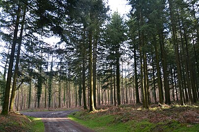
Forest road on Maupuy

Old quarry on Maupuy

View from Maupuy to the northeast towards Guéret
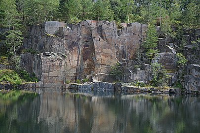
Former granite quarry standing under water

Panorama
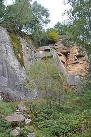
Demolition wall


.jpg)
.jpg)
.jpg)
.jpg)
.jpg)
Individual evidence
- ↑ , M .: Berthier, F., Duthou, JL and Roques Data Transportation géochronologique Rb / Sr sur roches total du granite de Gueret (Massif Central). Age fini-dévonien de mise en place de l'un de ses faciès types. In: Bulletin BRGM . tape 2 , 1979, p. 60-71 .
- ↑ C. Cartannaz: Magmatisme et deformation polyphasées: exemple of the massifs de Gueret et de Millevaches (Massif central français). Origine des magmas et contexte de mise en place. (Doctoral thesis) . Besançon 2006, p. 276 .