McAdam (New Brunswick)
| McAdam | ||
|---|---|---|
| Location in New Brunswick | ||
|
|
||
| State : |
|
|
| Province : | New Brunswick | |
| County: | York County | |
| Coordinates : | 45 ° 36 ′ N , 67 ° 20 ′ W | |
| Height : | 146 m | |
| Area : | 14.47 km² | |
| Residents : | 1284 (as of 2011) | |
| Population density : | 88.7 inhabitants / km² | |
| Time zone : | Atlantic Time ( UTC − 4 ) | |
| Postal code : | E6J | |
| Area code : | +1 506 | |
| Foundation : | 1966 | |
| Mayor : | Frank M. Carroll | |
| Website : | www.mcadamnb.com | |
McAdam is a village in York County in the Canadian province of New Brunswick . The population in 2011 was 1284 people.
geography
McAdam is on New Brunswick Route 4 . Fredericton is around 65 kilometers to the northeast, Woodstock around 75 kilometers to the north. The US state of Maine begins eight kilometers to the west.
history
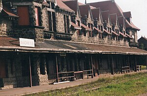
The first settlers settled in the middle of the 19th century and initially mainly operated the timber industry. The place was named after the politician John McAdam. With the connection to the Canadian Pacific Railway , McAdam experienced a significant boom. Railway connections to St. Stephen , St. Andrews and Woodstock, among others , became possible and it became a central location for supplying coal and water for many steam locomotives . After the switch to diesel locomotives in the 1950s, the stopovers in McAdam became largely unnecessary and the population of the place was noticeably reduced. The historic McAdam Train Station with an integrated hotel is listed on the National Historic Sites of Canada in New Brunswick and is now a museum and tourist attraction.
Web links
- mcadamstation - McAdam Railway Station

