Olewiger Bach
|
Olewiger Bach section name sequence : Oleigenbach → Franzenheimer Bach → Grundbach → Olewiger Bach → Altbach |
||
|
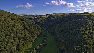
Valley of the Olewiger Bach between Franzenheim and Olewig. Facing south |
||
| Data | ||
| Water code | EN : 2652 | |
| location | Rhineland-Palatinate , Germany | |
| River system | Rhine | |
| Drain over | Moselle → Rhine → North Sea | |
| source | between Pellingen and Lampaden at the foot of the Dreikopf | |
| muzzle | in Trier-Süd Coordinates: 49 ° 44 ′ 41 ″ N , 6 ° 37 ′ 39 ″ E 49 ° 44 ′ 41 ″ N , 6 ° 37 ′ 39 ″ E
|
|
| length | 15.6 km | |
| Catchment area | 37.703 km² | |
The Olewiger Bach , which successively bears the names Oleigenbach , Franzenheimer Bach , Grundbach , Olewiger Bach and finally Altbach , is a 15.6 km long right tributary of the Moselle in Trier . It rises between Pellingen and Lampaden at the foot of the Dreikopf , flows through Franzenheim and past Hockweiler towards Trier-Kernscheid . Then it reaches Trier-Olewig and flows to Trier-Heiligkreuz . In the Altbachtal there was a Gallo-Roman temple district with about 70 individual buildings on an area of about 5 hectares, which is one of the largest cult areas in Central Europe. Today there is an allotment garden.
The Altbach flows further through Trier-Süd and flows out where the Hohenzollernstrasse meets the Pacelliufer and the St. Barbara-Ufer.
The water catchment area is 37.7 km², 10.5 of which are accounted for by the 9.8 km long Menscherbach (also Tiergartenbach im Unterlauf, Kandelbach im Oberlauf) with the left tributaries Holtz and Rotbach , which is at the north end of the street Im Tiergarten from opens on the left. Previously open from right shock Bach , dome Steinerbach , God Bach , Geißbach and Brettenbach , but only drain of less than one square kilometers to 2.6 (God Bach).
Legend says that the Olewig district takes its name from the Olewig brook. The first Christians are said to have been baptized here in Trier, and an oil film is said to have formed on the brook due to the anointing. The name comes from the Latin of 'Ole' and 'Via' and means something like 'Oil Way'.
Trier city stream
A branch of the Olewiger Bach is the Trier Stadtbach. According to historical maps, it flowed over the site of what would later become the police headquarters on Südallee and on along Weberbach , Liebfrauenstrasse , Domfreihof , Sternstrasse , Hauptmarkt and Simeonstrasse in the direction of Maarviertel . The Stadtbach flows into the Moselle near today's hospital mill . Between the early 19th and early 20th centuries, the Stadtbach was almost completely built over.
See also
Footnotes
- ↑ a b c GeoExplorer of the Rhineland-Palatinate Water Management Authority ( information )

