Mindelheimer Köpfl
| Mindelheimer Köpfl (Hüttenkopf) | ||
|---|---|---|
|
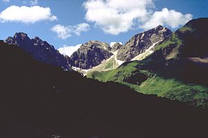
Mindelheimer Köpfl (rock peaks to the left of the rock summit on the left edge of the picture) from the northeast, from the path from the Wildental to the Fiderepaßhütte . To the left of it the six-pronged tip . Other rock peaks from left to right: Angererkopf (rock peak in the center of the picture with the small rock head next to it on the right), Liechelkopf (the highest rock peak). |
||
| height | 2180 m | |
| location | Bavaria / Vorarlberg border | |
| Mountains | Allgäu Alps | |
| Coordinates | 47 ° 17 '42 " N , 10 ° 11' 32" E | |
|
|
||
| rock | Main dolomite | |
| First ascent | unknown | |
| Normal way | pathless | |
The Mindelheimer Köpfl (also Hüttenkopf ) is a 2,180 m high, subordinate mountain in the Allgäu Alps . It lies between the six-pronged tip in the northeast and the Angererkopf in the southwest. Strictly speaking, the Mindelheimer Köpfl is just a point in the ridge of the six-pronged tip.
There is no marked path to the Mindelheimer Köpfl. All climbs require climbing experience. Due to its proximity to the hut, the Mindelheimer Köpfl is like the six-pronged tip of the climbing garden of the Mindelheimer hut .
literature
- Thaddäus Steiner : Allgäuer Bergnames , Lindenberg, Kunstverlag Josef Fink, 2007, ISBN 978-3-89870-389-5
- Thaddäus Steiner: The field names of the municipality of Oberstdorf im Allgäu , Munich, self-published by the Association for Field Name Research in Bavaria, 1972
- Zettler / Groth: Alpine Club Guide Allgäu Alps . Bergverlag Rudolf Rother , Munich 1984. ISBN 3-7633-1111-4

