Six-pronged tip
| Six-pronged tip | ||
|---|---|---|
|
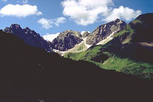
Sechszinkenspitze (rock summit on the left edge of the picture) from the northeast, from the path from the Wildental to the Fiderepasshütte . Further rock peaks from left to right: Mindelheimer Köpfl (tip to the left of the striking notch), Angererkopf (rock peak in the center of the picture with the small rock head to the right), Liechelkopf (the highest rock peak). |
||
| height | 2191 m | |
| location | Bavaria / Vorarlberg border | |
| Mountains | Allgäu Alps | |
| Coordinates | 47 ° 17 '49 " N , 10 ° 11' 40" E | |
|
|
||
| rock | Main dolomite | |
| First ascent | unknown | |
The six- pronged peak is a 2,191 m high mountain in the Allgäu Alps . The multi-jagged mountain lies west of the Mindelheimer Hütte between the Angererkopf in the southwest and Kemptner Köpfle in the northeast. The southwestern point of the mountain is also called Mindelheimer Köpfl .
There is no marked path to the six-pronged tip. All climbs require climbing experience. Due to its proximity to the hut, the six-pronged tip is the climbing garden of the Mindelheimer hut.
literature
- Thaddäus Steiner : Allgäuer Bergnames , Lindenberg, Kunstverlag Josef Fink, 2007, ISBN 978-3-89870-389-5
- Thaddäus Steiner: The field names of the municipality of Oberstdorf im Allgäu , Munich, self-published by the Association for Field Name Research in Bavaria, 1972
- Zettler / Groth: Alpine Club Guide Allgäu Alps . Munich, Bergverlag Rudolf Rother 1984. ISBN 3-7633-1111-4

