
Miratovac
|
Миратовац Miratovac Miratoc / Miratoci |
|||||
|
|||||
| Basic data | |||||
|---|---|---|---|---|---|
| State : | Serbia | ||||
| Province : | Central Serbia | ||||
| Okrug : | Pčinja | ||||
| Coordinates : | 42 ° 16 ' N , 21 ° 40' E | ||||
| Residents : | 2,774 (2002) | ||||
| Telephone code : | (+381) 0 (17) | ||||
| Postal code : | 17523 | ||||
| License plate : | VR | ||||


Miratovac ( Serbian - Cyrillic Миратовац , Albanian Miratoc / Miratoci ) is a village in Opština Preševo in Serbia , which lies directly on the border with North Macedonia . Miratovac is the southernmost town in Serbia (excluding Kosovo ).
geography
Miratovac is one of the largest settlements in the Preševo valley . The place is located south of the city of Preševo . To the west are the forests of the Skopska Crna Gora Mountains ( Albanian Malet e Karadakut ), through which the border with Kosovo runs. Since the break-up of Yugoslavia , the border between Serbia and Macedonia has been running south of Miratovac, separating culturally and historically interconnected places within the Preševo Valley. The village of Miratovac is also separated from the town of Preševo by two small rivers that flow eastwards from the mountains: the Lumi Čukarkes and the Lumi i Trnaves, which flows through the middle of the village of Trnava . In the north Miratovac borders on Trnava and in the northeast on the villages of Trnavska Reka , Cakanovac and Čukarka . In the east, the A1 motorway ( E 75 ) runs parallel to Lumi Čukarkes . Behind it are Momince and Strezovce . To the southeast in North Macedonia is the village of Tabanovce , where the main border crossing between North Macedonia and Serbia is located. To the south is the village of Lojane .
In Miratovac there is mainly agriculture , especially tobacco growing . The arable fields are suitable for grain and maize and are mainly along the Banjka . This river has its source not far from the village, flows to Macedonia and is then called Tabanovska Reka , before it joins the Lipkovska Reka in Kumanovo and thus becomes the Kumanovska Reka . This finally flows into the Pčinja , which flows over the Vardar into the Thermaic Gulf .
history
Freedom of movement within the Preševo valley is restricted by the drawing of the border in 1991. Family connections could not be maintained due to temporary border closings.
During the refugee crisis in 2015 , Miratovac came into international media due to its location on the Balkan route and the border between Serbia and Macedonia.
The inhabitants of this village are predominantly Albanian Muslims, for whom two mosques were built.
population
According to the 2002 census, the village had 2774 inhabitants, of whom 2731 (98.45%) considered themselves Albanians and 13 Serbs .
City structure
The districts of Miratovac are:
- Fezllaret
- Kajoshet
- Lenget
- Maloket
- Punaret
- Qoset
- Father
- Xhagaduret
- Xhelepet
- Xhuxhet
- Hasët
gallery

Small bus and taxi station in the direction of Preševo
New mosque and the southern district of Punaret

Miratovac from the border near Tabanovce

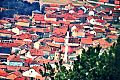
City center


Individual evidence
- ↑ Ethnic composition of Serbia 2002. In: pop-stat.mashke.org. Retrieved May 3, 2018 .