Mittelbach (Autenbach)
| Mittelbach | ||
|
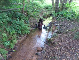
Miniature mill wheel on Mittelbach |
||
| Data | ||
| location |
Spessart
|
|
| River system | Rhine | |
| Drain over | Autenbach → Aschaff → Main → Rhine → North Sea | |
| source | in Mittelborn, southeast of Waldaschaff 49 ° 57 ′ 39 ″ N , 9 ° 20 ′ 2 ″ E |
|
| Source height | 306 m above sea level NHN | |
| muzzle | in Waldaschaff from the left and southeast in the Autenbach Coordinates: 49 ° 58 ′ 27 " N , 9 ° 18 ′ 32" E 49 ° 58 ′ 27 " N , 9 ° 18 ′ 32" E |
|
| Mouth height | 201 m above sea level NHN | |
| Height difference | 105 m | |
| Bottom slope | 40 ‰ | |
| length | 2.6 km | |
| Catchment area | approx. 3.4 km² | |
The Mittelbach is a left tributary of the Autenbach in the district of Aschaffenburg in the Bavarian Spessart .
geography
course
The Mittelbach rises in Mittelborn, southeast of Waldaschaff in the Waldaschaff Forest . It runs through the middle distance in a north-westerly direction, operates a miniature mill wheel and flows between the Kauppen on the left and the Römmelberg on the right to Waldaschaff, which stretches up half a kilometer into its lower valley along the Mittelthalstraße. There it flows into the Autenbach .
The brook runs almost from its source, accompanied by wood on the banks, through a meadow valley between mountains that are mostly wooded from the middle slope.
Catchment area
The Mittelbach has a catchment area of about 3.4 km², which extends from its highest point on the Weißensteiner Höhe to 482 m above sea level. NHN more than 4 km to the northwest to the mouth at about 210 m above sea level. NHN in Waldaschaff extends. The right watershed runs towards the Autenbach , beyond the northern foothills of the Eichhöhe ( 472 m above sea level ) of the Weißensteiner Höhe, the Hafenlohr arises in the east of the Mittelbach origin . The very close left watershed separates the Kleinaschaff from the valley .
Aschaff river system
See also
Web links
- The Mittelbach and its catchment area on the BayernAtlas
Individual evidence
- ↑ a b c Bavaria Atlas of the Bavarian State Government ( notes )
- ↑ measured on the Bayern Atlas .
- ^ Historical maps of the BayernAtlas
