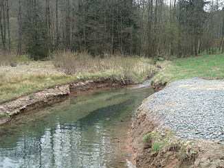
Autenbach
| Autenbach | ||
|
The Autenbach in front of Waldaschaff on Triftdamm |
||
| Data | ||
| Water code | DE : 2475412 | |
| location |
Spessart
|
|
| River system | Rhine | |
| Drain over | Aschaff → Main → Rhine → North Sea | |
| source | between Waldaschaff and Rothenbuch 49 ° 58 ′ 45 ″ N , 9 ° 20 ′ 44 ″ E |
|
| Source height | 308 m above sea level NHN | |
| confluence | with the Kleinaschaff to Aschaff Coordinates: 49 ° 58 ′ 21 ″ N , 9 ° 18 ′ 2 ″ E 49 ° 58 ′ 21 ″ N , 9 ° 18 ′ 2 ″ E |
|
| Mouth height | 189 m above sea level NHN | |
| Height difference | 119 m | |
| Bottom slope | 32 ‰ | |
| length | 3.7 km | |
| Catchment area | 12.7 km² | |
| Left tributaries | Mittelbach | |
|
Confluence of Kleinaschaff (left) and Autenbach (front) to Aschaff (to the rear) |
||
The Autenbach is the almost four kilometers long right source brook of the Aschaff in the district of Aschaffenburg in the Bavarian Spessart . Some do not refer to the Autenbach as a source brook of the Aschaff, but only as a side brook.
geography
course
The Autenbach rises in Autenborn , a larger spring on the road between Waldaschaff and Rothenbuch , at the foot of the Eselshöhe ridge , in the Waldaschaffer Forest . The source is located on the Autenborn campsite of the same name. Further down in the valley, the Autenbach passes a Trift dam. Then he feeds some ponds that were created to fish the Spessart trout. The Mittelbach flows into Waldaschaff and the Autenbach merges with the Kleinaschaff to form the Aschaff .
Tributaries
- Mittelbach (left)
Aschaff river system
Wood drift

The Autenbach was used to run the Trift at the beginning of the 18th century. The term wood drift refers to the rafting or transport of short pieces of firewood with the help of the water of streams and rivers. Towards the end of winter, the Trift master dammed the water in the Trift pond. Then the pieces of wood, which were mainly needed for the supply of Aschaffenburg , were thrown into the Autenbach and the drain on the dam opened. The raftsman had to ensure that the logs swiftly swam to the wood yard on the lower reaches of the Aschaff. The Trift dam on the Autenbach above Waldaschaff is one of the few testimonies to this tradition. This was renovated in 2011. The impressive dam made of hewn sandstone blocks is a listed building.
See also
Web links
- The Autenbach and its catchment area on the BayernAtlas
Individual evidence
- ↑ a b c Bavaria Atlas of the Bavarian State Government ( notes )
- ↑ Map service water management, WFD Bavarian State Office for the Environment ( information )
- ↑ Historical maps of the BayernAtlas (first recording 1808–1864)


