
Moalandlsee
| Moalandlsee | ||
|---|---|---|

|
||
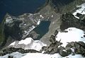
| Moalandlsee from the north | ||
| Geographical location | Imst district , Tyrol , Austria | |
| Drain | Schitzbach → Pitze | |
| Data | ||
| Coordinates | 47 ° 2 '11 " N , 10 ° 53' 6" E | |
|
||
| Altitude above sea level | 2525 m above sea level A. | |
| surface | 1.9 ha | |
| length | 270 m | |
| width | 100 m | |

The Moalandlsee is a mountain lake in the Geigenkamm in the Ötztal Alps . This is a Karsee , it is located at an altitude of 2525 meters above the Pitztal and northwest of the Hundstalkogel .
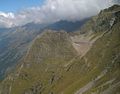
The ascent to the lake leads from Piösmes in the Pitztal first to the Luibisalm , which is not managed. Passing a hunting lodge, you reach the Luibis bottom , where the path to the lake branches off from the ascent to the Luibiskogel to the south. Now at first steeply, through a cirque and over a notch you reach the Moalandlsee. The route takes about 3 hours.
The surrounding mountains of the Geigenkamm are in the south of the Sturpen , in the east the Hundstalkogel towering high above the lake, in the west the Grabkogel and in the northwest the Wildgratenkogel.
from the northern summit of the Hundstalkogel

from the south summit of the Hundstalkogel
from stumbling


Literature and map
- Walter Klier : Alpine Club Guide Ötztaler Alpen , Bergverlag Rudolf Rother, Munich 2006. ISBN 3-7633-1123-8
- Alpine club map sheet 30/5, 1: 25,000, Ötztal Alps, Geigenkamm , ISBN 3-928777-44-0