
Luibiskogel
| Luibiskogel | ||
|---|---|---|
 Luibiskogel from the southwest, from the Hundstalkogel |
||
| height | 3110 m above sea level A. | |
| location | Tyrol , Austria | |
| Mountains | Ötztal Alps | |
| Dominance | 3.1 km → Wilde Geige | |
| Notch height | 473 m ↓ Breitlehnjöchl | |
| Coordinates | 47 ° 2 '58 " N , 10 ° 54' 13" E | |
|
||
| First ascent | August 5, 1894 by Max Peer and Ludwig Prochaska (tourist) | |
| Normal way | Southeast ridge ( I ) | |

The Luibiskogel (also called Loibiskogel ) is a double- peaked mountain in the Geigenkamm in the Ötztal Alps . The higher south summit measures 3110 m above sea level. A. The northern summit used to measure 3,090 m , but is about 30 meters lower after a landslide in 1999. The Luibiskogel can hardly be seen either from the neighboring Pitztal or from the Ötztal and the mountain only reveals its full size from higher vantage points.
Routes
The Luibiskogel can be reached on the following routes:
- from the Pitztal from Piösmes via the uncultivated Luibisalm, the Luibisscharte and the western part of the Hauerferner,
- from the Ötztal from Längenfeld via the Innerbergalm, the uncultivated Hauerseehütte and the Hauerferner.
The last part of both climbs is identical, both climbs require surefootedness and climbing skills of the 1st degree. From the edge of the Hauerferner to the southeast of the mountain, turn on the marked route to the northwest, over scree slopes in the direction of the steep mountain flank that you reach on the northern edge of the scree ridge. Now climb up over ribbons in a light climb, following the markings. It is possible to secure yourself using bolts that are installed regularly. You finally reach the southeast ridge, which is partly made up of slabs lying loosely on top of each other, and over this broad ridge in easy climbing the summit with the summit cross and summit book.
The Hauerferner is not a serious problem (anymore) on the way out of the Pitztal, but the ascent from the Pitztal is quite long and lonely. On the way out of the Ötztal, the Hauerferner can cause problems with blank ice , but it is then possible to bypass it in the scree next door.
Impressions
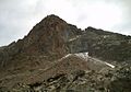
Luibiskogel from the southwest
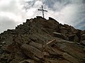
On the southeast ridge

View to the north summit in 2007 after the landslide


literature
- Walter Klier : Alpine Club Guide Ötztaler Alpen , Bergverlag Rudolf Rother, Munich 2006. ISBN 3-7633-1123-8
- Richard Goedeke : 3000er in the Northern Alps , Bruckmann, Munich 2004, ISBN 3-7654-3930-4
Web links
- Dr. Josef Hauser, Dr. Gunther Heißel, DI Christian Weber and Mag. Martin Schönherr: Mass movements from the point of view of the authorities and their experts. (PDF; 2.3 MB) Retrieved on September 7, 2008 (contains, inter alia, photos of the rockslide on the Luibiskogel).
Individual evidence
- ↑ Clem Clements, Jonathan de Ferranti, Eberhard Jurgalski , Mark Trengove: The 3000 m SUMMITS of AUSTRIA - 242 peaks with at least 150 m of prominence , October 2011, p. 9.
- ↑ Federal Office for Metrology and Surveying Austria: Luibiskogel on the Austrian Map online (Austrian map 1: 50,000) .
- ^ W. Klier: Alpenvereinsführer Ötztaler Alpen , page 80, see literature
- ^ W. Klier: Alpenvereinsführer Ötztaler Alpen , margin number 920, see literature