Monnerich
| coat of arms | map |
|---|---|

|

|
| Basic data | |
| State : |
|
| Coordinates : | 49 ° 32 ' N , 5 ° 59' E |
| Canton : | Esch on the Alzette |
| Residents : | 6959 (January 1, 2019) |
| Area : | 21.4 km² |
| Population density : | 325.2 inhabitants / km² |
| Municipality number: | 0208 |
| Website: | www.mondercange.lu |
| politics | |
| Mayor: | Jeannot Fürpass (CSV) |
| Elective system : | Proportional vote |
Monnerich ( Luxembourgish Monnerëch , French Mondercange ) is a municipality in the Grand Duchy of Luxembourg and belongs to the canton of Esch an der Alzette .
history
The town of Mondercange is probably one of the oldest in the Grand Duchy, as it is mentioned in an official act in 965 that the transfer of the rights of Count Siegfried to the village in favor of the abbey of Echternach. The first Christian church from the 10th century probably stood near the present church.
In 1989 the remains of a huge Roman property (villa rustica) were discovered and archaeological excavations were organized by the National Museum. This discovery proves that the village has existed since Gallo-Roman times.
Due to its exposed geographic location (between the Duchy of Luxembourg and Lorraine), Mondercange had a rather eventful history throughout the Middle Ages.
But the dawn of modern times brought little improvement. Witch trials took place in the late 16th century, and in 1620 the plague cut the population by half. The village fell to ashes several times as a result of the looting of the mercenaries involved in the frequent wars of the 17th century.
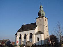
Nevertheless, the 18th century, and especially the Austrian rule under Empress Maria Theresa, significantly improved the quality of life not only for the villagers but also for the entire country. At this time (1738) the "new" church was built, which can still be admired today and was classified as a "national monument" because of its typical baroque architecture.
In 1804 the town of Mondercange had 80 houses, Bergem 20 and Pontpierre and Foetz 21. There were 21 "poor" and 3 "beggars".
The development of the steel industry at the end of the 19th century, which turned neighboring towns such as Esch-sur-Alzette, Differdange or Dudelange into real small towns, had only a superficial impact on the localities of the municipality of Mondercange. which was mainly characterized by agriculture. Only after the Second World War, and particularly in the 1970s and 1980s, did a real population explosion occur.
In 1900 the city of Mondercange had 1,016 inhabitants, in 1930 there were 1,365 and 1960 2,200. Today the city has 6,250 inhabitants.
Composition of the community
The municipality of Monnerich consists of the following localities:
- Bergem ,
- Fötz ,
- Monnerich
- Stone bridges .
church
The Catholic parish church of St. Willibrord dates from 1738. The baroque building replaces an older structure. In 2004 the church got a new organ from the Oberlinger workshop with 26 registers and two manuals. It was featured on a postage stamp by the Luxembourg Post in 2014.
various
Monnerich is the seat of the Luxembourg Football Association . The only go- kart track in Luxembourg that Michael Schumacher trained on as a teenager is located in Monnerich .
Personalities
Sons and daughters of the church
- Hubert Loutsch (1878–1946), politician
- Tom Laterza (born 1992), football player
Personalities who have worked on site
- Heinrich Wilhelm Breidenfeld (1794–1875), German organ builder
Individual evidence
- ↑ STATEC Luxembourg - Population par canton et commune 1821–2019 (French)
- ^ Postage stamp ( Memento from April 2, 2015 in the Internet Archive )
