
Montelaterone

Montelaterone is a district of Arcidosso in the province of Grosseto , Tuscany region in Italy .
geography
Montelaterone is 685 m and has about 280 inhabitants. The place is about 3 km northwest of the main town Arcidosso and 2 km west of the municipality of Castel del Piano . The provincial capital Grosseto is approx. 35 km southwest, the former ruling city of Siena approx. 50 km north. The Torrente Ente flows around the place to the east, the Zancona flows around Montelaterone to the west. The town center is stepped within two city wall rings (12th and 13th centuries), of which two city gates can still be seen in Via di Mezzo , and is divided into three contrades: Rocca (yellow-red colors, upper part), Porta (White-sky-blue coat of arms, middle part) and Valle (green-pink, lower part of the village).
history
Since the 9th century Montelaterone belonged to the monastery of San Salvatore di Monte Amiata , the place was first documented in December 915 in a diploma from Berengar I. Initially, the place was subordinate to the Pieve di Santa Maria a Lamula , which was part of the monastery of San Salvatore di Monte Amiata belonged to. In 1203 the monk Ronaldo promised territorial rights to Orvieto , but only two years later the inhabitants of Montelaterone submitted to the Republic of Siena. These confirmed that it belonged to Siena in 1217 and 1254. In the run-up to the Battle of Montaperti , the place was taken by the Aldobrandeschi fighting for Florence , but shortly afterwards it was recaptured by Siena. As a result, the Cassero Senese , a fortification at the highest point of the place, which was completed in 1265. The Abbey of San Salvatore regained a strong influence on the place at the end of the 13th century. It was not until 1369, with the construction of the new Cassero, that power in the town passed completely to Siena. After the victory of Florence over Siena in 1555, the place remained under the rule of the government-in-exile in Montalcino (Repubblica di Siena in Montalcino) until the Peace of Cateau-Cambrésis in 1559 and then became part of the Grand Duchy of Tuscany . With the territorial reform of Pietro Leopoldo d'Asburgo-Lorena in 1776 , Montelaterone became part of Arcidosso.
Attractions

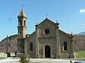
- Chiesa di San Clemente , church in the center, first mentioned in 1302. Was expanded in the 16th century, creating the chapels Cappella di San Cristoforo (1514) and that of the Compagnia di Corpus Domini . At the same time it received the baptismal font from the Pieve di Santa Maria a Lamula , making it the most important church in the town. On the main altar is the canvas painting Dolenti e San Clemente in adorazione della Croce by Francesco Nasini (1673).
- Palazzo Pretorio , palace from the 14th century that has been rebuilt several times. On the facade are the coats of arms of Podestà Cristoforo Cristofori (1473), Niccolò di Bogino (1505) and Forese dei Foresi di Siena (1543).
- Roccaccia , also called Cassero Senese , fortifications built between 1260 and 1265 by the Republic of Siena. The new cassero was built in 1369 on the site of the first cassero and was also built by the Republic of Siena. Today's castle ruins are at the highest point in the village.
- Chiesa di Santa Vittoria , first mentioned in 1293 near the Rocca, no longer exists today.
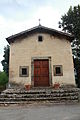
- Chiesa della Madonna della Misericordia , also called Madonna delle Grazie , church just outside the town center. Made in 1664 and restored in 1907. Contains by Francesco Nasini the frescoes and wall paintings Madonna della Misericordia ei santi Antonio abate, Pietro, Bartolomeo e Giacomo (back wall), Santi Sebastiano, Francesco e Rocco (right side), Redentore and Evangelisti (vault), Dio Padre e Angeli and Pietà ( all 1664).
- Cappella di Santa Lucia a Stiacciaie , chapel in the lower part of the village, which was built in the 15th century. Contains the fresco Madonna col Bambino and others.
- Pieve di Santa Maria a Lamula , Pieve , which is on the road to Arcidosso. In the 9th century it belonged to the monastery of San Salvatore di Monte Amiata . Was damaged by Senese troops in conflict with the Aldobrandeschi in 1265 and restored three years later. It was the most important church in Montelaterone until the 16th century, when the baptismal font was moved to San Clemente. Between the 17th and 19th centuries, the Pieve had to endure various architectural changes in style.
photos
The Pieve di Santa Maria a Lamula

The Chiesa della Madonna della Misericordia church
The Cappella di Santa Lucia a Stiacciaie


literature
- Giuseppe Guerrini / Amministrazione Provinciale di Grosseto: Torri e Castelli della provincia di Grosseto. Nuova Immagine Edizioni, Siena 1999, ISBN 88-7145-154-6 , p. 136
- Lucio Niccola / Fiora Bonelli: Paesi dell'Amiata , Cesare Moroni Edizioni, 2003, p. 60 f.
- Emanuele Repetti: MONTE LATERONE, o MONTE LATRONE, talvolta Saxum Laterone, nella Valle dell'Orcia. In: Dizionario Geografico Fisico Storico della Toscana (1833–1846). Online version of the University of Siena (pdf, Italian)
- Felicia Rotundo / Bruno Santi: Arcidosso. In: Bruno Santi: Guida Storico-Artistica alla Maremma. Nuova Immagine Edizioni, Siena 1995, ISBN 88-7145-093-0 , p. 199 ff.
- Bruno Santi: I luoghi della Fede. L'Amiata e la Val d'Orcia. Arnoldo Mondadori Editore , Milan 1999, ISBN 88-04-46780-0
- Touring Club Italiano : Toscana. Milan 2003, ISBN 88-365-2767-1 , p. 687.
Web links
Individual evidence
- ↑ Official website of the ISTAT ( Istituto Nazionale di Statistica ) for the districts 2001 in the province of Grosseto, accessed on April 12, 2015 (Italian)
- ↑ a b c Emanuele Repetti: MONTE LATERONE, o MONTE LATRONE, talvolta Saxum Laterone, nella Valle dell'Orcia.
- ↑ a b c d e f Bruno Santi (Ed.): I luoghi della Fede. L'Amiata e la Val d'Orcia.
- ↑ a b c Felicia Rotundo / Bruno Santi: Arcidosso. In: Bruno Santi: Guida Storico-Artistica alla Maremma.
Coordinates: 42 ° 53 ' N , 11 ° 31' E