Montgelasstrasse
| Montgelasstrasse | |
|---|---|
| Street in Munich | |
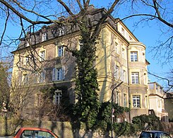
| Montgelasstrasse 2, a neo-baroque corner building | |
| Basic data | |
| State capital | Munich |
| Borough | Bogenhausen |
| Name received | 1897 |
| Connecting roads | Max-Joseph-Bridge , Herkomerplatz |
| Cross streets | Neuberghauser Strasse, Mauerkircherstrasse , Steinbacherstrasse, Kufsteiner Strasse, Möhlstrasse , Törringstrasse, Herzogparkstrasse, Gustl-Waldau-Steig |
| Places | Herkomerplatz |
| Numbering system | Orientation numbering |
| Buildings | Bundesfinanzhof (access from Ismaninger Strasse ) |
| tram | Line 16 |
| use | |
| User groups | Pedestrian traffic , bicycle traffic , individual traffic , public transport |
| Technical specifications | |
| Street length | 750 m |
The Montgelasstraße is a Innerorts- and Arterial Road in Munich . It leads from the "lower" Bogenhausen to the heights on the eastern Isar high bank and connects the northern Lehel with Bogenhausen.
course
The road begins at the Max-Joseph-Brücke , which was built in 1901 on the site of an older bridge that was destroyed by floods , designed by Theodor Fischer and crosses the Isar (also known as Bogenhausener Brücke and popularly known as Tivoli Bridge). From here, Mauerkircherstraße branches off to the north into the Herzogpark and northwards past Neuberghausen with the former Bad Brunnthal. It continues up the eastern Isar high bank, passes the junction of Möhlstrasse , runs below the Federal Fiscal Court (former site of Stepperg Castle (Munich) , the Montgelasschlössl ), with its library located in the park on Montgelasstrasse, and finally opens into Herkomerplatz , where Ismaninger Strasse and Oberföhringer Strasse converge and Bülowstrasse continues to Effnerplatz . Tram line 16 runs through the street and meets line 17 at Herkomerplatz.
designation
The street has been named after Maximilian Joseph de Garnerin, Count von Montgelas , the creator of modern Bavaria at the beginning of the 19th century, who owned a small castle nearby , since 1897 .
Architectural monuments in Montgelasstrasse
literature
- Hans Dollinger : The Munich street names. 6th edition, Südwest Verlag, Munich 2007, ISBN 978-3-517-08370-4 , p. 214.
- Willibald Karl, Karin Pohl: Bogenhausen (series: Time travel into old Munich, published by the Munich City Archives), Volk Verlag Munich 2014, with numerous. histor. Fig., ISBN 978-3-86222-113-4 .
Individual evidence
- ^ Hans Dollinger: Die Münchner Strasseennamen, 6th edition 2007, Südwest Verlag, Munich, ISBN 978-3-517-08370-4 , p. 214
Coordinates: 48 ° 9 ′ 0 ″ N , 11 ° 36 ′ 24 ″ E
