
Mooserboden reservoir

The Mooserboden reservoir is located above the municipality of Kaprun in the Hohe Tauern in the state of Salzburg in Austria .
The reservoir is an annual reservoir with a surface of 1.6 km² and a usable volume of max. 84.9 million m³. The water is collected from a catchment area of 99.3 km², the majority of which is melt water from the Pasterzen glacier of the Großglockner . This melt water is collected in the Margaritze reservoir in Carinthia and fed through the 11.5 km long Möll transfer tunnel into the Mooserboden reservoir.
In the upper stage of the Kaprun power plant , the water is used to generate electricity. The target is at an altitude of 2036 m above sea level. A. , the lowering target to 1960 m above sea level. A.
The reservoir was created from the construction of the two dams Moosersperre (in the west) and Drossensperre (in the east) from 1947 to 1955. Between the two dams lies the Höhenburg rock ( 2108 m above sea level ).
Barriers
| Surname | Type | Wall height | Crown length | Crown width | Max. Width of the base | Concrete cubature |
|---|---|---|---|---|---|---|
| Moosersperre | Gravity dam | 107.0 m | 494 m | 7 m | 70 m | 670,000 m³ |
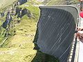
| Throttle lock | Vault dam | 112.0 m | 357 m | 7 m | 25 m | 340,000 m³ |
When the water is completely blocked, the walls of the two dams bend 5 cm outwards.

Throttle lock
Moosersperre


Historical


“Built with Marshall Plan Help” plaque on the dam

Historical AV map Fuscher Kamm, 1891 - the Moserboden high alpine pasture with a group of alpine huts and the mighty glaciation of the entire Glockner group

The pagan church on Mooserboden in Kaprun is a memorial by the sculptor Josef Magnus. The work of art with the inscription “From work and sacrifice one work” commemorates all the workers who died in an accident and lost their lives during the construction of the Kaprun power plant group.

This memorial plaque was placed in 2003 on the memorial of the sculptor Josef Magnus on Mooserboden in Kaprun, which was named as the Pagan Church. It commemorates over 120 forced laborers who perished during the construction of the Kaprun power plant group between 1940 and 1945.


See also
Web links
Coordinates: 47 ° 9 ′ 45 ″ N , 12 ° 43 ′ 3 ″ E