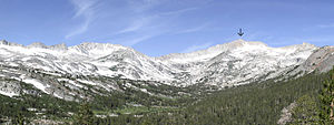
Mount Conness
| Mount Conness | ||
|---|---|---|
| height | 3839 m | |
| location | California , United States | |
| Mountains | Sierra Nevada | |
| Dominance | 11.27 km → Mount Dana | |
| Notch height | 801 m | |
| Coordinates | 37 ° 58 ′ 1 ″ N , 119 ° 19 ′ 18 ″ W | |
|
|
||
| Normal way | over the Young Lakes , grade 2 | |
| particularities | highest mountain in the Sierra Nevada north of the Tioga Pass | |
The Mount Conness is a 3839 m high mountain in the Sierra Nevada in the State of California of the United States . It lies on the border between Mono County and Tuolumne County and is considered the highest mountain in the Sierra Nevada north of the Tioga Pass .
The mountain is named after the American politician John Conness . The almost vertical southwest face can be seen from many parts of California State Route 120 (Tioga Pass) and is popular with rock climbers. Yosemite National Park stretches to the west of the summit and the Hoover Wilderness to the east . On its north side is the Conness Glacier , the second largest glacier in Yosemite National Park after the glacier on Mount Lyell . To the west is Roosevelt Lake and runs along Conness Creek , to the east is Saddlebag Lake .
Peaks in the area are Sheep Peak and North Peak in the north, White Mountain in the south and Ragged Peak in the southwest. The dominance is 11.27 km, so the mountain is the highest point in a 11.27 km radius. It is dominated by Mount Dana to the southeast .
Web links
- Mount Conness in the Geographic Names Information System of the United States Geological Survey
- Data on the mountain
Individual evidence
- ↑ a b c d summitpost.org : Mount Conness . Accessed March 1, 2019
- ↑ a b peakbagger.com : Mount Conness, California . Accessed March 1, 2019

