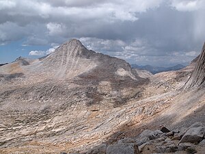
Mount Gabb
| Mount Gabb | ||
|---|---|---|
|
Mount Gabb as seen from the east |
||
| height | 4190 m | |
| location | California , United States | |
| Mountains | Sierra Nevada | |
| Dominance | 6.88 km → Mount Morgan | |
| Notch height | 786 m | |
| Coordinates | 37 ° 22 '37 " N , 118 ° 48' 9" W | |
|
|
||
| First ascent | 1917 | |
| Normal way | Class 2-3 | |
The Mount Gabb is a 4190 m high mountain in the Sierra Nevada in the State of California of the United States . It is located in Fresno County in the John Muir Wilderness . The mountain is named after the American paleontologist William More Gabb and was first climbed in 1917 by H. H. Bliss and A. L. Jordan .
Surroundings
There are two valleys to the north and south, with Mills Creek , which flows into Lake Thomas A Edison a few kilometers away , in the north and Lake Italy in the south. Peaks in the area are Mount Mills in the northeast, Mount Abbot and Mount Dade in the east, Bear Creek Spire and Mount Julius Caesar in the southeast, Mount Hilgard in the southwest, and Recess Peak in the northwest. The dominance is about 6.88 km, so the mountain is the highest elevation within a 6.88 km radius. It is dominated by Mount Morgan, which lies east-northeast .
Web links
- Mount Gabb in the United States Geological Survey's Geographic Names Information System
- Data on the mountain
Individual evidence
- ↑ a b summitpost.org : Mount Gabb
- ↑ a b peakbagger.com : Mount Mills, California . Accessed March 6, 2019

