Mount Mageik
| Mount Mageik | ||
|---|---|---|
|
Mount Mageik (left) and Mount Martin (right) |
||
| height | 2165 m | |
| location | Alaska Peninsula ( USA ) | |
| Mountains | Aleutian chain | |
| Coordinates | 58 ° 11 '44 " N , 155 ° 15' 12" W | |
|
|
||
| Type | Stratovolcano | |
| Last eruption | 500 BC Chr. | |
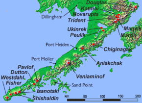
The Mount Martin is a 2165 m high stratovolcano of the Aleutian Range on the Alaska Peninsula . It belongs to Katmai National Park and borders the Valley of Ten Thousand Smokes in the south.
There are no confirmed records of historical eruptions . A possible 1946 eruption is now being questioned. The most recent volcanic deposits come from the Holocene . Sulfur-containing volcanic exhalations in the form of fumaroles can now be found on a young crater on the northeastern flank .
The volcano is covered in volcanic ash that came from the eruptions of Novarupta (1912) and Mount Trident (1953).
Web links
Commons : Mount Mageik - collection of images, videos and audio files
- Mount Mageik in the Global Volcanism Program of the Smithsonian Institution (English)
- Information about Mount Mageik (Alaska Volcano Observatory)


