Mount Meru
| Mount Meru | ||
|---|---|---|
| height | 4562.13 m | |
| location | Tanzania , East Africa | |
| Mountains | Edge of the East African Rift | |
| Coordinates | 3 ° 14 '38 " S , 36 ° 44' 53" E | |
|
|
||
| Type | Stratovolcano | |
| Last eruption | 1910 | |
| First ascent | 1904 by Fritz Jaeger | |
The Mount Meru is a volcano in the north of Tanzania in East Africa .
geography
With an officially 4562.13 meters (sometimes also given as 4630 or 4566 meters) height, Mount Meru is the third highest mountain in Tanzania and thus one of the highest mountains in Africa . The mountain is about 65 kilometers in a south-westerly direction from Kilimanjaro . It is surrounded by the Arusha National Park . South of the mountain is the city of Arusha . Like the Kilimanjaro massif, Mount Meru was created by volcanic activity along the East African Rift Valley.
Surname
Mount Meru belonged to the colonial area of German East Africa and was explored by Carl Uhlig in 1901 and first climbed by Fritz Jaeger in 1904 . The mountain Maeru was written in the German colonial times . In colonial literature, Dönjo Erok ("dark mountain") is given as the Maasai name . The highest peak of Mount Meru has been called Socialist Peak under Julius Nyerere since the socialist times of Tanzania in 1961 .
outbreaks
The mountain was originally much higher, but lost a large part of its summit due to a volcanic eruption in ancient times.
About 6000 years ago there was a violent eruption, similar to the eruption of Mount St. Helens in 1980 . The east wall of the crater collapsed, causing a stream of water, mud, and stones to pour east into the steppe. The Momella Lakes were formed during this eruption .
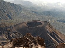
In the 1880s, there was a minor eruption from which the so-called Ashcone (German: ash cone ) originates, a smaller crater inside the large crater. The last minor eruption was in 1910. The caldera is 3.5 kilometers in diameter.
Rockclimbing
The ascent does not require any special technical skills, but surefootedness is required. The ascent is possible in three days. Because of its proximity to Kilimanjaro, Mount Meru stands in the shadow of its neighbor for tourists. However, it is often used for habituation and acclimatization, in order to then climb Kilimanjaro.
Mountain huts
There are two mountain huts, the Miriakamba hut ( 2514 m ) and the saddle hut ( 3500 m ).
The Miriakamba Hut ( English Miriakamba Hut ) is the first stage destination of the Mount Meru ascent with two sleeping huts for tourists and one sleeping hut for the porters. The kitchen is in a separate hut. There are also two toilet houses. It's about three to five hours' walk from Momela Gate .
The Sattelhütte (English Saddle Hut ) is achieved hike on the second day after about three to four hours. The hut is located in a saddle between Rhino Point ( 3800 m ) and Little Meru ( 3801 m ). As a short excursion, the latter can be reached in about 45 minutes on the same day. This is recommended both for the beautiful view and for better altitude acclimatization.
From the Saddle Hut you usually set off for the summit stage in the middle of the night and reach Rhino Point (3,800 meters) after an hour. After another five hours you are on the summit.
population
The Meru live in the towns and villages near the mountain .
Web links
- Mount Meru in the Global Volcanism Program of the Smithsonian Institution (English)
- Mount Meru at Peakware (English)
- Satellite images of Mount Meru (English)


