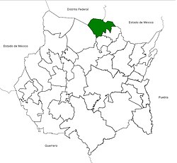
Municipio Tlalnepantla
| Tlalnepantla | ||
|---|---|---|

|
||
| Symbols | ||
|
||
| Basic data | ||
| Country | Mexico | |
| State | Morelos | |
| Seat | Tlalnepantla | |
| surface | 108.2 km² | |
| Residents | 6636 (2010) | |
| density | 61.3 inhabitants per km² | |
| Website | tlalnepantlamor.gob.mx | |
| INEGI no. | 17023 | |
| politics | ||
| Presidente municipal | Fausto Rubio Pillado | |
Coordinates: 19 ° 1 ′ N , 98 ° 59 ′ W
Tlalnepantla is a municipality in the north of the Mexican state of Morelos , about 50 km south of the center of the Mexican capital Mexico City . The main town and largest town in the municipality is Tlalnepantla of the same name . The municipality had 6,636 inhabitants at the 2010 census, the area of the municipality amounts to 108.2 km².
geography
The Municipio Tlalnepantla is located in the north of the state at an altitude of 1700 m to 3500 m in the Sierra Volcánica Transversal . It borders on the municipalities of Tlayacapan , Totolapan and Tepoztlán , on the municipality of Juchitepec in the state of México and on Milpa Alta in the federal district of Mexico City .
About 50% of the community area is forested, another 40% is used for agriculture.
places
The municipality of Tlalnepantla comprises 11 localidades , of which only the main town is classified as urban by the INEGI .
| places | Residents |
| Tlalnepantla | 3,872 |
| Felipe Neri | 1,338 |
| El Vigía | 832 |
| El Pegregal | 507 |
| Fraccionamiento los Robles | 35 |
| Fraccionamiento Calmil | 22nd |
| Campo los Jagüeyes | 9 |
| Bosques de Morelos | 8th |
| Campo Tepehuaxtitla | 7th |
| Campo Cuauyeca | 4th |
| Fraccionamiento Hacienda Villa Campestre | 2 |
Web links
- Enciclopedia de los Municipios y Delegaciones de México: Municipio Tlalnepantla (Spanish)
- INEGI : Datos Geográficos: Municipio Tlalnepantla (Spanish; PDF)

