Municipio Vallecillo (Nuevo León)
| Vallecillo | |
|---|---|

|
|
| Basic data | |
| Country | Mexico |
| State | Nuevo León |
| Seat | Vallecillo |
| surface | 1,768.1 km² |
| Residents | 1971 (2010) |
| density | 1.11 inhabitants per km² |
| INEGI no. | 19050 |
| politics | |
| Presidente municipal | Arnulfo de León Villarreal |
Coordinates: 26 ° 42 ′ N , 100 ° 0 ′ W
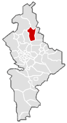
Vallecillo is a municipality in the Mexican state of Nuevo León . The seat of the municipality is the Vallecillo of the same name . The municipality had 1971 inhabitants in 2010, its area is 1768 km² .
geography
The municipality of Vallecillo is located in the north of the state of Nuevo León, about halfway between Monterrey and Nuevo Laredo . The municipality is located at an altitude between 100 m and 600 m in the catchment area of the Río Bravo del Norte . INEGI counts 93% of the parish area to the physiographic region of the Great Plains and 7% to the Sierra Madre Oriental . The predominant soil type is calcisol with 51% . 65% of the municipality is taken up by Dornsavanne , 33% is used for agriculture, mainly for livestock.
The municipality borders on the municipalities Lampazos de Naranjo , Anáhuac , Parás , Agualeguas and Sabinas Hidalgo as well as on the state of Tamaulipas .
places
The Municipio Vallecillo comprises 91 localidades , five of which have more than 100 inhabitants.
| places | Residents |
| Vallecillo | 622 |
| Palo Alto | 284 |
| El Álamo | 226 |
| Los Colorados de Abajo | 222 |
| San Carlos | 140 |
Web links
- Enciclopedia de los Municipios y Delegaciones de México: Municipio Vallecillo (Spanish)
- INEGI : Datos Geográficos: Municipio Vallecillo (Spanish; PDF)
