
Mutschen
| Mutschen | ||
|---|---|---|
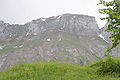
 Mutschen to the left of the striking Chrüzberg , to the far left of the Gätterifirst |
||
| height | 2121 m above sea level M. | |
| location | Gams , St. Gallen , Switzerland | |
| Mountains | Alpstein | |
| Dominance | 0.23 km → Roslen-Saxer First | |
| Notch height | 53 m ↓ Mutschensattel | |
| Coordinates | 748 988 / 233525 | |
|
||
| rock | limestone | |

The Mutschen with 2121 m above sea level. M. is a peak in the Alpstein region in the Swiss canton of St. Gallen and is the highest peak in the first chain of the massif that is visible from the bottom of the Rhine Valley. The community of Gams , whose highest point it is, has a share on the south side, while the northwestern flank is the community area of Wildhaus and the northeast side belongs to the community of Sennwald .
The Mutschen himself is nevertheless not very independent; it is surmounted by both the Chreialpfirst and the Rosten- / Saxerfirst immediately behind it, but the two ridges are behind the Mutschensattel in the next area chamber and cannot be seen from the bottom of the Rhine Valley.
The Mutschen can be reached from Gams via Obetweid or via the Mutschensattel via the Saxer Lücke . Another option is to climb out of the Wildhaus in Toggenburg. The ascent from Mutschensattel to the summit is easy for hikers too. The date of the first ascent is not known. The mountain was probably climbed very early as part of hunting and herding .
photos

Mutschen, view of Gasenzen

Mutschen, view of Gasenzen, on the right the Mutschensattel
Mutschen, view from the Schwendi
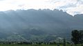
Mutschen as the highest point seen from the valley floor in the center of the picture, to the right of it the Chrüzberg and on the right edge of the picture the Saxer Lücke


