Nabental waterfall
| Nabental waterfall | ||
|---|---|---|
|
"Failure structure" at the branching Nabetaler Graben |
||
| Coordinates | 51 ° 48 '3.2 " N , 10 ° 30' 36.8" E | |
|
|
||
| place | Altenau-Schulenberg in the Upper Harz , Clausthal-Zellerfeld , Goslar District , Lower Saxony , Germany | |
| Falling watercourse | Hub (→ Kellwasser → Oker ) | |
| Estuarine waters | Nabetaler Graben → Dammgraben → Oker | |
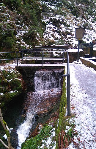
The Nabentaler waterfall in the Harz , also called Nabetaler waterfall in some documents , is located west of Torfhaus in the non-parish Harz region ( district of Goslar , Lower Saxony ) and consists of two parts. The almost inaccessible lower waterfall lies in a short steep gorge, in which the small brook Nabe has cut into the trough valley wall of the uppermost Kellwassertal . The name applies above all to the upper part, a cataract stretch in the course of supply lines to the dam ditch . Thus it is part of the Upper Harz water shelf .
Geographical and water management situation
The Nabentaler waterfall is located in the Harz National Park not far from the steep wall , a cirque wall on the northern slope of the Bruchberg between Torfhaus and Altenau . Above, the road L504 ("Steile-Wand-Straße") runs between Altenau and Torfhaus with connection to the federal road 4 . At the level of this street, the water of the Clausthal flood ditch flows into the bed of the hub. In its bed, it forms the steep section that follows the falling terrain, which is known as the Nabentaler waterfall . This name can already be found in 1873. Below the "waterfall" the Nabentaler Bach or the Nabe is dammed and mostly introduced into the Nabetaler Graben , which begins here, through a failure structure . The beginning of the Nabetaler trench is about 40 meters above the dam trench.
At the lower end of the Nabental waterfall, the Harzer Hexenstieg hiking trail crosses a bridge and runs along the historic Magdeburger Weg .
Since the Nabentaler waterfall almost exclusively carries water from the Clausthaler Flutgraben and has only a very small catchment area of its own , it can be regarded as an artificially created structure that was created in 1827. The waterway Clausthaler Flutgraben - Nabentaler Wasserfall - Nabetaler Graben was created in order to feed more water to the dam ditch. Nabetaler Graben and Dammgraben are part of the Upper Harz Water Management World Heritage Site .
During heavy rain, a lot of sediment in the form of sand and gravel can be channeled into the Nabentaler Graben through this steep section. In order to limit this, closing the existing gate can prevent the polluted water from entering the Nabetaler Graben, so that the water and sediments flow downhill into the Großer Spritzental.
Below the junction of the Nabentaler trench, the part of the water that has not been cut off flows on in the bed of the hub and then falls steeply into the Kellwassertal. The hub under the overpass structure of the Dammgraben feed line from the Kellwassertal forms a natural waterfall a few meters high. It is located off the beaten track in the Harz National Park , in difficult-to-access terrain.
Autumn storms 2017
After storms Xavier and Herwart in autumn 2017, the bridge at the Nabental waterfall is impassable. The hiking trail on the Magdeburger Weg side was washed away.
literature
- Martin Schmidt : The water management of the Upper Harz mining industry . 3. Edition. Harzwasserwerke, Hildesheim 2002, ISBN 3-00-009609-4 (series of publications by the Frontinus Society, issue 13).
- Hugo Haase : Engineering structures of old water management in the Upper Harz . 5th edition. Pieper, Clausthal-Zellerfeld 1985, ISBN 3-923605-42-0 .
- Gerhard Lisowsky: Walks on Dammgraben , Clausthal-Zellerfeld 1968, pp. 24-27.
- Gerhard Laub: The Nabentaler waterfall , in: General Harz Mountain Calendar 2001, pp. 30–32.
Web links
See also
Individual evidence
- ^ Meyer's travel books, 1873, p. 170
- ↑ Martin Schmidt: WasserWanderWege, a guide through the Upper Harz water shelf - world cultural heritage . Ed .: Harzwasserwerke GmbH. 4th edition. Papierflieger Verlag, Clausthal-Zellerfeld 2012, ISBN 978-3-86948-200-2 , p. 79-80 .


