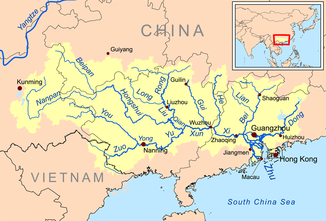
Nanpan Jiang
|
Nanpan Jiang 南 盘 江 |
||
|
Pearl River (Zhu Jiang) river network |
||
| Data | ||
| location | Guizhou , Yunnan , Guangxi ( PR China ) | |
| River system | Pearl river | |
| Drain over | Hongshui He → Qian Jiang → Xun Jiang → Xi Jiang → (partly Pearl River) → South China Sea | |
| Association with |
Beipan Jiang to Hongshui He Coordinates: 24 ° 57 ′ 22 " N , 106 ° 8 ′ 28" E 24 ° 57 ′ 22 " N , 106 ° 8 ′ 28" E
|
|
| length | 856 km | |
| Catchment area | 56,200 km² | |
|
Nanpan Jiang, Yiliang 2012 |
||
The Nanpan Jiang River ( Chinese 南 盤 江 / 南 盘 江 , Pinyin Nánpánjiāng ) rises in the east of the southwest Chinese province of Yunnan on the border with the provinces of Guizhou and Guangxi .
Its source is in the area of Zhanyi County of Qujing at the eastern foot of Maxiong Shan 马 雄 山 , from there it flows south to Kaiyuan , then north-east. In Wangmo County in Guizhou Province , it unites with the Beipan Jiang 北 盘 江 to form the Hongshui He 红 水河 , the left tributary of the West River (Xi Jiang, 西江 ). The Nanpan Jiang has a length of 856 km, its catchment area is 56,200 square kilometers. It flows through a limestone area . The larger hydropower plants include the Tianshengqiao power plant and the Lubuge power plant.
Individual evidence
- ↑ Cihai ("Sea of Words"), Shanghai cishu chubanshe, Shanghai 2002, ISBN 7-5326-0839-5 , p. 1214.

