Northern Velebit National Park
| Northern Velebit National Park | ||
|---|---|---|
| Look into the distance | ||
|
|
||
| Location: | Lika-Senj , Croatia | |
| Specialty: | Speleology , deepest vertical direct shaft in the world | |
| Next city: | Senj and Otočac | |
| Surface: | 109 km² | |
| Founding: | 1999 | |
| Visitors: | unknown | |
| Address: |
www.np-sjeverni-velebit.hr HR-53 274 Krasno Tel. +385 53 665 380 |
|
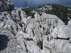
| typical karst forms | ||
The Northern Velebit National Park ( Croatian : Nacionalni park Sjeverni Velebit ) was declared a national park in 1999 and is located in the northern part of the Velebit mountain range near the town of Senj on the Croatian Adriatic Sea .
The area is 109 square kilometers. The national park offers wonderful viewpoints, high climbing rocks and numerous caves . In 1992 Lukas Grotto was discovered there, the deepest known cave in Southeast Europe at the time (1392 m). The region with its magnificent karst formations is a worthwhile destination for hikers using the Premužićeva staza long-distance hiking trail , mountaineers ( Hajdučki i Rožanski kukovi ), cave explorers (Lukina Jama), botanists (Botanical Garden at Zavižan ) and nature lovers in general. The national park lies within the "Velebit Mountain" biosphere reserve of UNESCO .
Web links
- Northern Velebit National Park (Croatian, German, English and Italian)
- Velebit Nature Park , not identical to the National Park - but older (1981) and more extensive (2000 km²)
- Interesting information on the subject of speleology (an even deeper cave)
- Hiking in Northern Velebit
- UNESCO: Velebit Biosphere Reserve (English)
- NATURA 2000 (Nature and Biodiversity Newsletter of the European Commission)
- European Destinations of Excellence (EDEN) award 2009 (English)
- Overview map


