Nepisiguit River
|
Nepisiguit River Rivière Népisiguit |
||
|
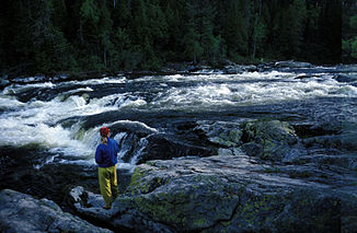
Canoeing on the upper reaches of the Nepisiguit River ( Nepisiguit Lakes in Mount Carleton Provincial Park ), in New Brunswick , Canada (IR Walker 1988) |
||
| Data | ||
| location | New Brunswick (Canada) | |
| River system | Nepisiguit River | |
| origin |
Nepisiguit Lakes 47 ° 23 '19 " N , 66 ° 43' 29" W. |
|
| Source height | approx. 305 m | |
| muzzle |
Bathurst Harbor , Chaleur Bay ( Gulf of Saint Lawrence ) Coordinates: 47 ° 37 ′ 15 " N , 65 ° 38 ′ 36" W 47 ° 37 ′ 15 " N , 65 ° 38 ′ 36" W |
|
| Mouth height | 0 m | |
| Height difference | approx. 305 m | |
| Bottom slope | approx. 2.4 ‰ | |
| length | approx. 125 km | |
| Catchment area | 2320 km² | |
| Discharge at the gauge Pabineau Falls A Eo : 2090 km² Location: 16 km above the mouth |
MQ 1958/1974 Mq 1958/1974 |
45.2 m³ / s 21.6 l / (s km²) |
| Right tributaries | Little South Branch Nepisiguit River, South Branch Nepisiguit River | |
| Small towns | Bathurst | |
|
Indian Falls |
||
The Nepisiguit River ( French Rivière Népisiguit ) is an approximately 125 km long tributary of the Gulf of St. Lawrence in the Canadian province of New Brunswick .
River course
The headwaters of the Nepisiguit River are to the east of Mount Carleton Provincial Park . The Nepisiguit River drains the 305 m high Nepisiguit Lakes . It flows almost 100 km to the east before turning north. It finally flows into Bathurst Harbor , an estuary in the south of Chaleur Bay at Bathurst . The course of the river lies in Northumberland and Gloucester Counties . Several waterfalls lie along the course of the river: Indian Falls (near Popple Depot), Nepisiguit Falls and Pabineau Falls . The Nepisiguit Falls are used to generate energy.
Hydrology
The Nepisiguit River drains an area of 2320 km². The mean discharge 16 km above the mouth is 45.2 m³ / s. In the months of April, May and June the river carries the largest amount of water with an average of 63.6, 181 and 63.6 m³ / s.
Web links
- Nepisiguit River at Natural Resources Canada
Individual evidence
- ↑ a b Natural Resources Canada - Rivers
- ^ A b c Government of Canada: Historical Hydrometric Data Search Results: Station 01BK004
- ^ Rayburn, A. (1975) Geographical Names of New Brunswick. Toponymy Study 2. Surveys and Mapping Branch, Energy Mines and Resources Canada, Ottawa
- ↑ Geographical Names of Canada - ( Memento of the original dated February 7, 2009 in the Internet Archive ) Info: The archive link was inserted automatically and has not yet been checked. Please check the original and archive link according to the instructions and then remove this notice.

