Newport-on-Tay
| Newport-on-Tay | ||
|---|---|---|
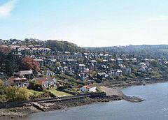
| Cityscape of Newport-on-Tay | ||
| Coordinates | 56 ° 27 ′ N , 2 ° 56 ′ W | |
|
|
||
| Residents | 4243 2011 census | |
| administration | ||
| Post town | NEWPORT-ON-TAY | |
| ZIP code section | DD6 | |
| prefix | 01382 | |
| Part of the country | Scotland | |
| Council area | Fife | |
| British Parliament | North East Fife | |
| Scottish Parliament | North East Fife | |
Newport-on-Tay is a city in the Scottish council area of Fife . It lies on the banks of the Firth of Tay across from Dundee about twelve kilometers northwest of St Andrews .
history
The city emerged as the landing site of a ferry from Dundee across the Firth of Tay, which has operated since at least the 12th century. Newport grew with the construction of a new port in 1820. The structure designed by Thomas Telford facilitated traffic to nearby and flourishing Dundee. In the following decades, commuting workers from the factories of Dundee settled in the area, initially referred to as New Dundee , and the town grew increasingly. In 1841 the population was 241, while by 1891 it had increased almost tenfold to 2548. In 2011 the city had 4243 inhabitants.
traffic
West of Newport-on-Tay, the Firth-of-Tay Bridge was completed in 1877 . Trains ran regularly from Newport to, among other places, Dundee. In 1879 the bridge collapsed in a storm, killing 75 people. The construction of a new bridge began a few years later. It was completed in 1887. In 1966, the Tay Road Bridge opened a road bridge between Newport and Dundee. This is where the A92 runs from Dunfermline via Glenrothes to Dundee city center and then on to Montrose and Stonehaven . The railway line via Newport has since been decommissioned.


