Nickerie (river)
| Nickerie | ||
|
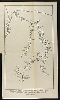
The river basin, map circa 1902 |
||
| Data | ||
| location | Suriname | |
| River system | Corantijn | |
| Drain over | Corantijn → Atlantic | |
| source | on the western slope of the Bakhuis Mountains 4 ° 20 ′ 30 ″ N , 57 ° 0 ′ 13 ″ W |
|
| muzzle | in the Corantijn coordinates: 5 ° 58 ′ 14 " N , 57 ° 0 ′ 56" W 5 ° 58 ′ 14 " N , 57 ° 0 ′ 56" W.
|
|
| Catchment area | 10,000 km² | |
| Left tributaries | Maratakka | |
| Small towns | Wageningen | |
|
The Nickerie behind the Nieuw-Nickerie market |
||
The Nickerie is a river in the northwest of Suriname , ( South America ), in the districts of Sipaliwini and Nickerie .
River course
The Nickerie rises on the western slope of the Bakhuis Mountains , near the headwaters of the Adampada watercourse. Flowing northwards it forms the Van Eden - and Blanche Marie - waterfalls and then makes a large west-east curve, where u. a. the Paris Jacob stream flowing on the left is added. Flowing to the north-east, it takes in the Mozes and Falawatra rivers, which also flow to the left, between the Lombok and drie Zusatz waterfalls as well as the Baas Bart and the Stondasi waterfalls . Behind the Stondasi Falls, the river flows into the coastal plain, takes the Arawara on the right , passes the local settlement of Tapoeripa , and on the border with the Coronie district - and taking in the Kofimaka Creek, it bends to the west. Behind Wageningen, where the Maratakka joins from the left , it flows through an agricultural area (mainly rice cultivation ) and finally reaches the Corantijn estuary and with it the Atlantic .
particularities
The river is navigable as far as Wageningen for ships with a draft of up to 4 m. However, the shallows in the estuary form an obstacle. The Nickerie has a catchment area of around 10,000 km².
exploration
The river basin was studied in the 19th century by Voltz (1854), Ten Kate (1885), Van Drimmelen (1897) and Van Capelle (1900). After 1945, the Centraal Bureau Luchtkartering (Central Office for Aerial Mapping) and the Geological Mijnbouwkundige Dienst (Geological and Mining Service) were responsible for the research.
literature
- CFA Bruijning and J. Voorhoeve (main editors): Encyclopedie van Suriname . Elsevier , Amsterdam a. Brussel 1977, ISBN 90-10-01842-3 , p. 428.

