
Niederwallufer Bay
|
Niederwallufer Bay
|
||
 left the Rhine, right the bay |
||
| location | between Niederwalluf and Wiesbaden-Schierstein on the Rhine | |
| surface | 13 ha | |
| Identifier | 1439041 | |
| WDPA ID | 318853 | |
| Geographical location | 50 ° 2 ' N , 8 ° 10' E | |
|
||
| Sea level | 83 m | |
| Setup date | August 28, 2000 | |

The Niederwallufer Bay is a nature reserve on the Rhine between Walluf and Wiesbaden-Schierstein in the German state of Hesse .
location
The 13 hectare protected area is located on the orographic right north bank of the Rhine in the natural area of Ingelheimer Rheinebene . The western part of the area is located in Niederwalluf ( Rheingau-Taunus district ), while the eastern part belongs to the Wiesbaden district of Schierstein , both of which are wine towns in the Rheingau . The bay is a still water zone that is separated from the main stream of the Rhine by a dam , and at the western end of which is the small port of Niederwalluf. A dam with a footpath and bike path runs north of the nature reserve, and behind it lies the Schierstein waterworks . To the east is the Bauernaue and the Schiersteiner Hafen . Budenheim is on the opposite side of the Rhine .
natural reserve
The aim of the nature reserve is to preserve the near-natural Rhine bank and softwood meadows in the Ingelheimer Rheinebene natural area. The bank area of the still water zone serves as a breeding, feeding and resting biotope for birds and a spawning area for herb spawners and small fish.

Aerial photo from 1953, still without trees

in the foreground the bay, behind it the Rhine
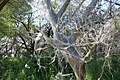
woven tree
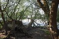
fallen trees on the shore
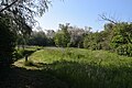
Meadow in the nature reserve

Niederwallufer harbor, in the background the nature reserve


See also
Web links
Individual evidence
- ^ Ordinance on the nature reserve "Niederwallufer Bucht" of August 28, 2000 . In: State Gazette for the State of Hesse , No. 40, October 2, 2000, pp. 3224–7.
- ↑ Nature reserves , website of the city of Wiesbaden, accessed on April 2, 2020.
