Nienhagen (Leopoldshöhe)
|
Nienhagen
Leopoldshöhe municipality
Coordinates: 52 ° 1 ′ 49 ″ N , 8 ° 40 ′ 22 ″ E
|
|
|---|---|
| Height : | 121 m |
| Area : | 2.44 km² |
| Residents : | 673 (December 31, 2018) |
| Population density : | 276 inhabitants / km² |
| Incorporation : | 1st January 1969 |
| Postal code : | 33818 |
| Area code : | 05208 |
|
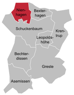
Location of Nienhagen in Leopoldshöhe
|
|
Nienhagen was an independent municipality and is now a district in the north-west of the municipality of Leopoldshöhe in the Lippe district . It borders the city of Bielefeld to the west and the city of Bad Salzuflen to the north .
geography
Nienhagen is located in the Ravensberger hill country and consists mainly of agricultural land.
history
Nienhagen was incorporated into the newly formed community Leopoldshöhe on January 1, 1969 as part of the community reform.
For many years, the image of Nienhagen was shaped by the agricultural properties lined up on Bielefelder Strasse. It was not until the 1970s that the first contiguous settlement was created, mainly with the help of the VdK , in which more than half of all Nienhagen residents live.
Individual evidence
- ↑ Martin Bünermann: The communities of the first reorganization program in North Rhine-Westphalia . Deutscher Gemeindeverlag, Cologne 1970, p. 68 .

