
Norðdepil


Norðdepil [ ˈnoːɹˌdeːpɪl ] ( Danish Norddeble ) is a place in the Faroe Islands on the island of Borðoy , which is one of the six northern islands . On January 1, 2016 there were 156 residents. The place belongs to the Faroese municipality Hvannasund ( Hvannasunds kommuna ). The zip code is FO-730.
history
Norðdepil was founded in 1866 by Poul Sivar Sivertsen from Hvannasund, who opened a business here after the monopoly trade in the Faroe Islands was abolished in 1856 and at the height of whaling . He initially called the place "á Oyrini". The later name Norðdepil is derived from the historical village Depil further south . The neighboring village of Fossá, founded at the same time, was later abandoned. In 1895 a school was opened. Two years later, in 1897, construction began on a Norwegian whaling station , which was in operation from 1898 to 1912. In 1920 the station was finally closed. The construction of the whaling station at the end of the 19th century brought the first rats to the island of Borðoy, of which the entire northern islands had remained undisturbed until then. In the second half of the 18th century rats had spread for the first time on the four large islands of Suðuroy, Streymoy, Vágar and Eysturoy, but the other islands were initially spared. After the first rats were introduced into Norðdepil in 1898, they spread to Viðoy and Kunoy until the First World War. Of the northern islands, only Fugloy, Svínoy and Kalsoy have remained rat-free bird paradises.
In August 1941, in heavy fog, a Junkers Ju 88 crashed on the highest rock face of the 755 m high Lokki Mountain in the immediate vicinity of the village. Remains of the aircraft were discovered at an altitude of 700 meters.
In 1960 the fish fillet factory Frostvirkið was built in the village , but had to close again in 1990 in the wake of the severe economic crisis. In 1963 the road embankment was opened that connects Norðdepil with the town of Hvannasund on Viðoy . Since both places are directly opposite each other, Norðdepil and Hvannasund are often considered one place. Since 1967 Norðdepil is, by two consecutive tunnels have been built across Borðoy between the East and West coasts with Klaksvík connected. Klaksvík is not only the capital and center of the North Islands, but also the second largest city in the Faroe Islands. Along the east coast of Borðoy, a road leads to Múli , a now abandoned village. The only traffic light on the North Islands is in Norðdepil .
In 1983 a new school with seven classes was finally opened, which is operated together with the neighboring town of Hvannasund.
photos

Entrance of the Hvannasund tunnel in Norðdepil.

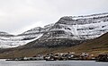
Norðdepil with the 755 m high Lokki in the background.
The place on a day in October.
,_entrance_to_Hvannasundstunnilin.jpg)

.jpg)
See also
Web links
- Søgan. hvannasund.fo
- Nógv á skránni nú Norðdepil fyllir 150 ár. portal.fo, August 14, 2016
- Don Brandt: Stamps i Danmark, p. 47. (PDF) faroestamps.fo. Archived from the original on May 25, 2011. Retrieved on August 9, 2016.
Individual evidence
- ↑ Fólkatalsbroytingar skiftar á FODD, deyð, flutt og bygd, mánaðarliga (1985-2016). hagstova.fo
- ↑ Hvussu gomul er bygdin. heimabeiti.fo
- ↑ Hvalastøðir í Føroyum 1894-1984. ( Memento of the original from August 9, 2016 in the Internet Archive ) Info: The archive link was inserted automatically and has not yet been checked. Please check the original and archive link according to the instructions and then remove this notice. savn.fo
- ↑ Rottan hóttir heimsins størsta drunnhvítabøli, og vit hava ábyrgdina (PDF) hav.fo
- ↑ Á slóðini hjá niðurdottnum Junkers 88 . ww2.fo
Coordinates: 62 ° 18 ′ N , 6 ° 31 ′ W