
Northern Province (Rwanda)
| Northern Province of Intara y'Amajyaruguru |
|
|---|---|
  |
|
| Basic data | |
| Country | Rwanda |
| Capital | Byumba |
| surface | 3436 km² |
| Residents | 1,726,370 (2012) |
| density | 502 inhabitants per km² |
| ISO 3166-2 | RW-03 |
Coordinates: 1 ° 35 ′ S , 30 ° 4 ′ E

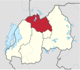
The Northern Province (in Kinyarwanda Intara y'Amajyaruguru , French Province du Nord , English Northern Province ) is a province of Rwanda . It was formed with the introduction of a new administrative structure on January 1, 2006 from most of the former provinces of Byumba and Ruhengeri and the northern part of Kigali Rural. The northern province consists of the five districts of Burera, Gakenke, Gicumbi, Musanze and Rulindo. Its capital is Byumba . According to the 2012 census, the province has 1,726,370 inhabitants.
geography
Another city is Ruhengeri . The landscape of the northern province is uneven and characterized by high mountains, including volcanoes of the Virunga volcanic chain . The highest point is the Karisimbi .
economy
Agriculture is the most important industry. There are two factories in the industry. In the mining sector, tungsten, coltan , tin, stones and sand are mined. Five transport companies take care of the public road transport, transport on water is possible on lakes and rivers. There are two major hydropower plants in Mukungwa and Ntaruka.
Web links
Individual evidence
- ^ Rwanda: Provinces, Cities & Places - Population Statistics in Maps and Tables. Retrieved April 6, 2018 .