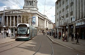
Nottingham Express Transit
| Nottingham Express Transit | |
|---|---|
| Basic information | |
| Country | Great Britain |
| city | Nottingham |
| opening | March 9, 2004 |
| operator | Nottingham Trams Ltd. |
| Web presence | thetram.net |
| Infrastructure | |
| Route length | 32 km |
| Gauge | 1435 mm ( standard gauge ) |
| Power system | 750 V DC overhead line |
| Stops | 50 |
| business | |
| Lines | 2 |
| vehicles | 15 Bombardier Incentro AT6 / 5, 22 Alstom Citadis 302 |
| Top speed | 80 km / h |
| statistics | |
| Passengers | 11.6 million per year (2015/16) |
| Route network | |||||||||||||||||||||||||||||||||||||||||||||||||||||||||||||||||||||||||||||||||||||||||||||||||||||||||||||||||||||||||||||||||||||||||||||||||||||||||||||||||||||||||||||||||||||||||||||||||||||||||||||||||||||||||||||||||||||||||||||||||||||||||||||||||||||||||||||||||||||||||||||||||||||||||||||||||||||||||||||||||||||||||||||||||||||||||||||||||||||||||
|---|---|---|---|---|---|---|---|---|---|---|---|---|---|---|---|---|---|---|---|---|---|---|---|---|---|---|---|---|---|---|---|---|---|---|---|---|---|---|---|---|---|---|---|---|---|---|---|---|---|---|---|---|---|---|---|---|---|---|---|---|---|---|---|---|---|---|---|---|---|---|---|---|---|---|---|---|---|---|---|---|---|---|---|---|---|---|---|---|---|---|---|---|---|---|---|---|---|---|---|---|---|---|---|---|---|---|---|---|---|---|---|---|---|---|---|---|---|---|---|---|---|---|---|---|---|---|---|---|---|---|---|---|---|---|---|---|---|---|---|---|---|---|---|---|---|---|---|---|---|---|---|---|---|---|---|---|---|---|---|---|---|---|---|---|---|---|---|---|---|---|---|---|---|---|---|---|---|---|---|---|---|---|---|---|---|---|---|---|---|---|---|---|---|---|---|---|---|---|---|---|---|---|---|---|---|---|---|---|---|---|---|---|---|---|---|---|---|---|---|---|---|---|---|---|---|---|---|---|---|---|---|---|---|---|---|---|---|---|---|---|---|---|---|---|---|---|---|---|---|---|---|---|---|---|---|---|---|---|---|---|---|---|---|---|---|---|---|---|---|---|---|---|---|---|---|---|---|---|---|---|---|---|---|---|---|---|---|---|---|---|---|---|---|---|---|---|---|---|---|---|---|---|---|---|---|---|---|---|---|---|---|---|---|---|---|---|---|---|---|---|---|---|---|---|---|---|---|---|---|---|---|---|---|---|---|---|---|---|---|---|---|---|---|---|---|---|---|---|---|---|---|---|---|---|---|---|---|---|---|---|---|
|
|||||||||||||||||||||||||||||||||||||||||||||||||||||||||||||||||||||||||||||||||||||||||||||||||||||||||||||||||||||||||||||||||||||||||||||||||||||||||||||||||||||||||||||||||||||||||||||||||||||||||||||||||||||||||||||||||||||||||||||||||||||||||||||||||||||||||||||||||||||||||||||||||||||||||||||||||||||||||||||||||||||||||||||||||||||||||||||||||||||||||
Nottingham Express Transit (NET for short) is a modern tram system that connects the English city of Nottingham and its suburbs. It was on 9. March 2004 by Transport Minister Alistair Darling opened at a cost of 200 million pounds . 16 years passed between the first plans and the opening.
The tram is operated by Nottingham Trams Ltd. operated and managed on behalf of the Tramlink Nottingham Consortium. From March 9, 2004 to December 16, 2011, it was operated by Arrow Light Rail, also a consortium. Arrow Light Rail was originally responsible for operating the system for 30 years; this did not prove successful.
history
Horse and steam trams operated in Nottingham from 1875 to 1897. In 1897 the network was electrified. The first generation of trams operated in Nottingham until 1936.
Route network
Phase 1
Opened in 2004, the tram route starts at Nottingham Central Station , south of the city center, runs north to Hucknall and is 14 km long. Four kilometers are on roads and ten are along railway lines. North of the city center there is a short branch route to Phoenix Park . There are park and ride facilities at several stops .
Phase 2
There were already expansion plans for two new lines under the project name NET Phase Two during phase 1. One should continue in a south-westerly direction to Chilwell and open up the University of Nottingham (it leads to Toton , the other to Wilford and Clifton ). The contracts with the Tramlink Nottingham consortium were originally supposed to be concluded in September 2011, the opening was planned for 2014. Due to various delays, it finally took place on August 25, 2015. The aim is to further relieve the roads and make four million car journeys unnecessary every year.
vehicles
The trams, built by Bombardier Transportation , run every five minutes during rush hour.
| Existing vehicles | ||||||||
| number | model series | image | V / max | length | Seats | Standing room | number | Construction year |
|---|---|---|---|---|---|---|---|---|
| 201-215 | Adtranz Incentro |

|
80 km / h | 33 m | 62 | 129 | 15th | 2002-2003 |
| 216-237 | Alstom Citadis |

|
70 km / h | 32 m | 58 | 144 | 22nd | 2013-2014 |
Web links
- Official NET website
- Image page about Nottingham's tram at public-transport.net
References and comments
- ↑ History made as new tram routes open ( Memento from September 21, 2015 in the Internet Archive )
