
Noviomagus Treverorum
| Noviomagus Treverorum | |
|---|---|
| limes | Protection in the hinterland, province of Gallia Belgica |
| Dating (occupancy) | A)? up to 275 B) constantinic up to? |
| Type | A) Street station B) Late antique fortress |
| size | A)? B) 131 × 112 m = 1.28 ha |
| Construction | A)? B) stone fort |
| place | Neumagen-Dhron |
| Geographical location | 49 ° 51 '4.6 " N , 6 ° 53' 40.7" E |
Noviomagus Treverorum was the name of a Roman settlement in the area of today's Neumagen-Dhron in Rhineland-Palatinate , where there was a road station in the imperial era and a fort in late antiquity .
swell
Noviomagus (Treverorum) is recorded both in the Tabula Peutingeriana (between Tabernis and Borgetomagi ) and in the Itinerarium Antonini (between Tabernis and Bormitomago ).
Around the year 371, the Roman poet Decimus Magnus Ausonius Noviomagus mentions Mosella in the tenth and eleventh lines of his travelogue written in hexameters :
Noiomagum, diui castra inclita Constantini
"And in the front country of the Belgians I finally saw Noviomagus, the famous castle of the divine Constantinus."
Location, findings and history
Noviomagus Treverorum was located in the province of Gallia Belgica on a narrowing of the Moselle valley on Ausoniusstraße , a trunk road that led from Augusta Treverorum to Bingium and had a connection there to the Rhine Valley road to Mogontiacum . At Noviomagus Treverorum a road leading from the hinterland of the Hunsrück flowed into Ausoniusstraße and there was a ship landing on the Moselle, as well as a ferry connection to the other bank of the Moselle. The place was a transshipment point and market for goods from the Hunsrück and was secured by a Roman road station. The Celtic / Latin name Noviomagus Treverorum can be roughly translated as "New Trever Market ". In the year 275 the place was destroyed by a German invasion.

A stone fortification was built in Constantinian times. In today's cityscape, its area is outlined by Spielesgasse in the north, Krischelsberg in the east, Burgstrasse in the south and Moselstrasse in the west. In the western area you can still see remains of the walling and two round towers ▼ . There, the community of Neumagen-Dhron and the local history and tourist association created an archaeological circular route in cooperation with the Rheinisches Landesmuseum Trier . In addition to the still visible remains of the fortifications, the individual stations along the way show replicas of the relief stones discovered in Neumagen (see below). The fortification consisted of a polygonal defensive wall, especially on the north side tending to oval, with the approximate dimensions of 112 by 131 m, which corresponds to a walled area of 1.28 hectares. The wall was occupied by 13 round towers protruding on both sides, each with a diameter of nine to ten meters. There were a total of two entrances with massive, flanking, rectangular gateways, one on the north and one on the south side of the fort. The Roman trunk road, whose course corresponds to today's “Roman road” (L156), led through these gates. Only an older, partially taken over square building with arcades facing the street is known of the fort's interior. In front of the gates, traces of approach obstacles in the form of a rampart and a ditch could be found.
Stone monuments
During the investigations on the fortress wall, which up to this point had been taken to be the medieval city wall, the archaeologists discovered in 1877 that the foundation of the wall consisted of secondary relief stones, inscription stones, figurative and other architectural elements. The excavations that followed lasted until 1885 and uncovered a real treasure trove of stone monuments. It took until 1932 before the complete collection of stones could be published in detail by the archaeologist Wilhelm von Massow on behalf of the Roman-Germanic Commission . Most of them were stones from former tombs from the period between the end of the first and the middle of the third century.
The reliefs show scenes from everyday life such as wine transport, everyday school life, personal hygiene, rent payment, hunting and the funeral meal, but also mythological motifs. The content, as well as the highly demanding craftsmanship of the stone carving, refer to a workshop that is more likely to be in the area of Augusta Treverorum than in the rural area around Noviomagus Batavorum. Science therefore assumes that the stones were broken off in the Augusta Treverorum burial grounds as part of a possible short-term defensive measure, transported by ship to Noviomagus, and there were used to build the foundation of the defensive wall.
Today the stone monuments are in the Rheinisches Landesmuseum Trier , where they have been partially reconstructed and put together to form a “grave road”, which is supposed to give an impression of the appearance and effect of the burial grounds in antiquity.
- Roman stone monuments from Noviomagus Treverorum
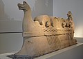
Sculpture of a ship transporting wine
(around 220)
FO: Neumagen-Dhron
AO: Rheinisches Landesmuseum Trier
Hairdressing scene, excerpt from the grave monument of a family (around 220)
FO: Neumagen-Dhron
AO: Rheinisches Landesmuseum Trier
School scene, part of a grave monument
(around 180/185)
FO: Neumagen-Dhron
AO: Rheinisches Landesmuseum Trier
Sculpture of a bear that beats a boar
(between 180 and 220)
FO: Neumagen-Dhron
AO: Rheinisches Landesmuseum Trier
Roman lease payment (around 205)
FO: Neumagen-Dhron
AO: Replica in Neumagen-Dhron (original: Rheinisches Landesmuseum Trier)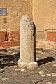
Leugenstein (212)
FO: Neumagen-Dhron
AO: in situ


.jpg)

literature
- Heinz Cüppers : Noviomagus Treverorum. Street station and fort . In Ders .: The Romans in Rhineland-Palatinate . Theiss, Stuttgart 1990. pp. 492-494.
- Wilhelm von Massow and Emil Drüger: The tombs of Neumagen . De Gruyter, Berlin 1932.
- Bernhard Numrich: The architecture of the Roman grave monuments from Neumagen. Contributions to chronology and typology . Trier magazine, supplement 22, Rheinisches Landesmuseum, Trier 1997, ISBN 978-3-923319-37-4 .
Web links
Individual evidence
- ↑ Ralf Scharf: The Dux Mogontiacensis and the Notitia Dignitatum. A study of late antique border defense . Reallexikon der Germanischen Altertumskunde , supplementary volume 50, de Gruyter, Berlin 2008, ISBN 978-3-11-019397-8 , p. 46.
- ↑ Ausonius, Mosella, 10-11.
- ↑ a b Heinz Cüppers: Noviomagus Treverorum. Street station and fort . In Ders .: The Romans in Rhineland-Palatinate . Theiss, Stuttgart 1990. p. 492.
- ↑ On the trail of Romans and Treverians. Archaeological circular route , on the website of the Neumagen-Dhron tourist information center, accessed on November 26, 2018.
- ↑ KJ Killes: Archaeological circular route. Roman new stomach. Noviomagus Treverorum. Info brochure from the Ferienland Bernkastel-Kues series , publisher: Municipality of Neumagen-Drohn, display 2018.
- ^ Wilhelm von Massow and Emil Drüger: The tombs of Neumagen . De Gruyter, Berlin 1932.
- ^ Heinz Cüppers: Noviomagus Treverorum. Street station and fort . In Ders .: The Romans in Rhineland-Palatinate . Theiss, Stuttgart 1990. p. 493.
- ^ Heinz Cüppers: Noviomagus Treverorum. Street station and fort . In Ders .: The Romans in Rhineland-Palatinate . Theiss, Stuttgart 1990. pp. 493f.
- ^ Heinz Cüppers: Noviomagus Treverorum. Street station and fort . In Ders .: The Romans in Rhineland-Palatinate . Theiss, Stuttgart 1990. p. 494.
- ↑ Leugenstein, Neumagen, community Neumagen-Dhron Römerstraße on the website "Database of cultural assets in the Trier region", accessed on November 25, 2018.