Noxubee River
| Noxubee River | ||
|
Noxubee River in Macon |
||
| Data | ||
| Water code | US : 694218 | |
| location | Mississippi , Alabama (USA) | |
| River system | Mobile River | |
| Drain over | Tombigbee River → Mobile River → Gulf of Mexico | |
| origin | Choctaw Lake 33 ° 16 ′ 18 ″ N , 89 ° 8 ′ 25 ″ W. |
|
| muzzle | in the Tombigbee River coordinates: 32 ° 49 ′ 43 " N , 88 ° 10 ′ 44" W 32 ° 49 ′ 43 " N , 88 ° 10 ′ 44" W. |
|
| Mouth height |
32 m
|
|
| length | 225 km | |
|
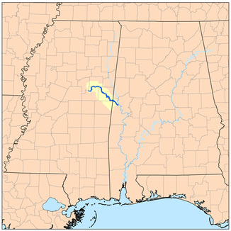
Course of the river and catchment area of the Noxubee River |
||
The Noxubee River [ ˈnɑksəbiː ] is a river about 225 kilometers long in east central Mississippi and west of central Alabama .
It is a tributary of the Tombigbee River , which flows into the Gulf of Mexico via the Mobile River .
course
The Noxubee rises in Choctaw Lake in the Tombigbee National Forest in Choctaw County and flows through counties: Winston , Oktibbeha and Noxubee and Sumter Counties in Alabama, through the Noxubee National Wildlife Refuge and past the city of Macon .
Different names
According to the Geographic Names Information System , the Noxubee River also goes by the following names:
|
|
Web links
swell
- Columbia Gazetteer of North America entry
- DeLorme (1998). Alabama Atlas & Gazetteer . Yarmouth, Maine: DeLorme. ISBN 0-89933-274-9 .
- DeLorme (1998). Mississippi Atlas & Gazetteer . Yarmouth, Maine: DeLorme. ISBN 0-89933-346-X .

