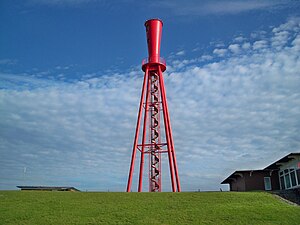
Oberfeuer Preußeneck
| Oberfeuer Preußeneck | ||
|---|---|---|
| Place: | Eckwarderhörne | |
| Location: | Lower Saxony , Germany | |
| Geographical location: | 53 ° 31 '15.7 " N , 8 ° 13' 56.9" E | |
| Fire carrier height : | 44.75 m | |
| Fire height : | 43.25 m | |
|
|
||
| Identifier : | Iso.W.3s | |
| Function: | Leading light | |
| Construction time: | 1962 | |
| Operating time: | 1962-2012 | |
| International ordinal number: | B1141.1 | |
The Preußeneck upper fire belongs to the former Eckwarden leading light line in the Inner Jade . It was decommissioned in 2012 and will be preserved as a monument .
The Eckwarden leading light line was put into operation in 1962 and marked the third section of the fairway to the Wilhelmshaven ports . The striking upper light was erected on the dike in Eckwarderhörne and the 18.4 m high lower light on a steel pipe in the mudflats off Butjadingen . The directional firing line was 154 ° and it exhibited as an identifier every three seconds, a white common-mode light (Iso.W.3s). The Waterways and Shipping Office was responsible for the operation .
For the new JadeWeserPort , the course of the Jade fairway had to be adjusted and the Jappensand leading light had to be built. When it went into operation on June 5, 2012, the Eckwarden leading light was switched off. The Jade-Weser-Port Realisierungsgesellschaft was responsible for the adjustment of the fairway and was also commissioned to demolish the old leading lights. In 2009 the citizens' initiative Leuchtfeuer Eckwarderhörne was founded , which campaigned for the maintenance of the upper fire.
While the lower fire was being dismantled, the demolition of the upper fire was suspended in October 2012 and the tower was subsequently handed over to the Oberfeuer Preußeneck Foundation . In 2017 the tower was renovated and partially rebuilt. A platform that is accessible to visitors was installed at a height of 18.4 meters. Another platform at a height of 34.5 meters is only accessible as part of guided tours. A documentation center was set up in the machine house of the former beacon.
The name Preußeneck comes from the time when Prussia also acquired around 2.2 hectares of land on the southwestern tip of Butjadingen with the Jade Treaty and Eckwarderhörne belonged to the jade area .
Web links
Individual evidence
- ↑ a b Oberfeuer Preusseneck. District newspaper Wesermarsch, accessed on November 6, 2014 .
- ↑ Eckwarden leading light line. WSA Wilhelmshaven, accessed on November 6, 2014 .
- ↑ Announcement for Seafarers 36/12. (No longer available online.) WSA Wilhelmshaven, June 5, 2012, archived from the original on November 7, 2014 ; accessed on November 6, 2014 . Info: The archive link was inserted automatically and has not yet been checked. Please check the original and archive link according to the instructions and then remove this notice.
- ↑ Foundation can start work. NWZ online , March 9, 2013, accessed November 6, 2014 .
- ↑ Detlef Glückselig: Everything ready for the reconstruction of the beacon. Nordwest-Zeitung, March 16, 2017, accessed August 7, 2017 .
- ↑ Silke Looden: Butjardingen peninsula - old lighthouse is a new attraction. Weser-Kurier, August 6, 2017, accessed on August 7, 2017 .

