
Oeder Kogel
| Oeder Kogel | ||
|---|---|---|
 Oeder Kogel from the Sattel to the Ostiner Berg from the south |
||
| height | 1135 m above sea level NN | |
| location | Bavaria , Germany | |
| Mountains | Bavarian Prealps | |
| Dominance | 0.34 km → Ostiner Berg | |
| Notch height | 27 m | |
| Coordinates | 47 ° 44 '5 " N , 11 ° 46' 35" E | |
|
||
| Normal way | Mountain hike, a short distance without a path, unmarked | |

The Oeder Kogel ( 1135 m ), or Oederberg , is a summit in the Tegernsee Mountains , which are part of the Bavarian Prealps . There is a small ski area at the foot of the Oeder Kogel.
topography
The Oeder Kogel, along with Gassler Berg , Schußkogel and Wallenburger Kogel, is part of a series of peaks in front of the Neureut - Gindelalm mountain range. The north side and the summit are forested. On the saddle between Oeder Kogel and Ostiner Berg there is a swamp meadow ; there is a headwaters of the Schussbach .
The Oeder Kogel is rarely visited, the swampy meadow on the saddle can be reached on foot or by mountain bike via forest paths from Ostin , but the last 30 meters in altitude must be covered without paths .
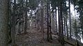
Summit area of the Oeder Kogel
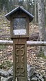
Torture for a soldier who was shot by poachers halfway up the summit from Ostin

