
Ogosta
| Ogosta | ||
 The upper reaches of the Ogosta |
||
| Data | ||
| Water code | BG : 312 | |
| location | Bulgaria | |
| River system | Danube | |
| Drain over | Danube → Black Sea | |
| source |
Tschiprowa Mountains 43 ° 20 ′ 23 ″ N , 22 ° 48 ′ 29 ″ E |
|
| Source height | 1660 m above sea level A. | |
| muzzle | North of Charlez coordinates: 43 ° 44 '46 " N , 23 ° 53' 7" O 43 ° 44 '46 " N , 23 ° 53' 7" O |
|
| Mouth height | 27 m | |
| Height difference | 1633 m | |
| Bottom slope | 11 ‰ | |
| length | 147.4 km | |
| Catchment area | 4227 km² | |
| Left tributaries | Binowraschki dol, Babitschki dol, Findo, Buchka, Wirowska reka, Madanska bara, Bŭrzina | |
| Right tributaries | Malki Bukovets, Sŭbrin dol, Parasinski dol, Rawnyanska bara, Barata, Zlatitsa, Turya bara, Bŭrziya, Shugawitsa, Botunya, Vŭrteshnitsa (Leva reka), Skŭt | |
| Reservoirs flowed through | Tschiprovzi reservoir, Ogosta reservoir | |
| Medium-sized cities | Montana | |
| Small towns | Tschiprowzi , Bojtschinowzi , Mizia , | |
| Navigable | No | |
The Ogosta (Bulgarian: Огоста, Romanian: Ogustul) is the largest river in northwestern Bulgaria and a right tributary of the Danube. According to the Cambridge Ancient History (CAH), the name Ogosta should be derived from the Latin Augusta .
geography
The Ogosta arises from two source rivers. The larger one has its source on the border with Serbia in the extreme western Balkans, also known in Bulgaria as the "Old Mountains", Stara Planina (Bulgarian: Стара планина ), known as the Tschiprowzi Mountains. The source is located at about 1760 m above sea level, according to other sources at 1660 meters above sea level. The source stream is called Tschiprowza-Bach (Bulgarian: Чипровска река ), after the influx of smaller bodies of water it is called Prewalska Ogosta (Bulgarian: Превалска Огоста ). South of the village of Martinowo (Bulgarian: Мартиново ) near Tschiprowzi (Bulgarian: Чипровци ), the river is dammed for the first time into a small, approx. 65,000 m² lake. The second source rises at the summit of Vražja Glava at an altitude of 935 m, also on the Serbian-Bulgarian watershed. It is called Dŭlgidelska Ogosta (Bulgarian: Дългоделска Огоста or Дългиделска Огоста ).
At Gavril Genovo (Bulgarian: Гаврил Геново ) the two source rivers flow together. Before Montana (Bulgarian: Монтана ) the river to the Ogosta reservoir is dammed. Behind Montana, the Ogosta flows in a northeasterly direction with little gradient towards the Danube. Shortly after Charlez (Bulgarian: Хърлец ), two kilometers before the mouth, the river was led into a new canal bed, some of the water still flows in the original river bed. The new river bed was built in 1970 to make way for the Kozloduy nuclear power plant (Bulgarian: Козлодуй ).
Since then, the largest tributary, the Skǎt (other spellings: Skat, Skŭt) (Bulgarian: Скът ), which previously flowed into the Danube, flows into the Ogosta at Saraewo (Bulgarian: Сараево ). After 147.4 km the Ogosta joins the Danube at river kilometer 685.
Hydrology
volume
The catchment area of the Ogosta covered 3,157.1 km² until 1970. Since the Skǎt became a tributary, it is 4,227 m². The Ogosta river system consists of a total of 40 tributaries. The average annual runoff in the mountains near the town of Tschiprovzi is 0.81 m³ / s. At the last level before it flows into the Danube at Mizia (Bulgarian: Мизия ) it is 25.4 m³ / s. The Ogosta has the most water during the snowmelt in spring and least in October.
| Amount of water | Jan | Feb | March | April | May | June | July | Aug | Sept | Oct | Nov | Dec | annual average |
|---|---|---|---|---|---|---|---|---|---|---|---|---|---|
| Amount (m 3 / s) | 22.80 | 31.60 | 45.60 | 48.30 | 49.60 | 33.60 | 14.30 | 7.01 | 10.10 | 5.91 | 15.50 | 20.20 | 25.40 |
| Quantity (% of the annual volume) | 7.49 | 10.38 | 14.97 | 15.86 | 16.29 | 11.03 | 4.70 | 2.30 | 3.32 | 1.94 | 5.09 | 6.63 | 100.0 |
Water quality
Although the river water is used as drinking water for neighboring communities, it suffers from pollution. The water of the Ogosta is heavily polluted with nitrate, which is washed in by the over-fertilization of the agricultural areas along the river. However, the upper reaches of the river in the mountains are pretty clean. Another reason for the pollution was the mining of gold in the upper catchment area of the Ogosta from 1950 to 1991. As a result, the river floor and the floodplain landscape surrounding the river were heavily contaminated with arsenic. In addition, the Ogosta is heavily contaminated with other heavy metals such as lead and zinc. The limit values are exceeded many times over.
Localities
The Ogosta flows through a rather sparsely populated part of Bulgaria. The only major city on its shores is Montana with 40,000 inhabitants. There are also the small towns of Tschiprowzi (Bulgarian: Чипровци ) with 2000 inhabitants upstream and downstream Bojtschinowzi (Bulgarian: Бойчиновци ) with 1500 inhabitants and Mizia (Bulgarian: Мизия ) with 3500 inhabitants. The following settlements are located on the Ogosta, viewed downstream (Bulgarian spelling in brackets):
Montana Oblast: Prewalska Ogosta
- Martinowo (Мартиново)
- Tschiprovtsi (Чипровци)
- Jelesna (Железна)
- Belimel (Белимел)
- Gavril Genowo (Гаврил Геново)
Dŭlgidelska Ogosta
- Dalgi Del (Дълги дел)
- Goweschda (Говежда)
- Melyane (Меляне)
- Georgi Damjanowo (Георги Дамяново)
- Gavril Genowo (Гаврил Геново)
Ogosta
- Montana (Монтана)
- Earth (Ерден)
- Bojchinovtsi (Бойчиновци)
- Portitowzi (Портитовци)
- Vladimirovo (Владимирово)
- Gromschin (Громшин)
- Letschewo (Лехчево)
- Beli Brod (Бели брод)
Wraza Oblast:
- Mihajlowo (Михайлово)
- Manastirishte (Манастирище)
- Hajredin (Хайредин)
- Kriwa Bara (Крива бара)
- Butane (Бутан)
- Sofroniewo (Софрониево)
- Gloschene (Гложене)
- Harlets (Хърлец)
use
In the lower reaches of the river near Mizia and near the city of Montana, the Ogosta is used for irrigation. A large irrigation project covering around 180,000 hectares was planned in 1966 when the construction of the Ogosta reservoir began. By 1989, however, only half of the necessary construction work had been carried out. No further construction work has been carried out since the end of the communist era; since irrigation is no longer profitable.
In the upper reaches of the Ogosta there are four hydropower plants, "Lopuschna", "Tschiprowzi" in the mountains and the power plants "Koscharnik" (Bulgarian: Кожарник ) and "Ogosta" (Bulgarian: Огоста ) at the Ogosta reservoir in Montana. Sand and gravel are taken from the river for construction purposes. The Ogosta reservoir serves as a leisure resort and fishing.
Sponsorship

Ogosta Point (Bulgarian: нос Огоста ) on the island of Livingston , part of the South Shetland Islands , Antarctica , was named by the Bulgarian Commission for Antarctic Geographical Names (Bulgarian: Komisija po antarktitscheskite naimenowanija Комисия камисия по ентарost ) after the Ogosta river.
The path of the river in pictures

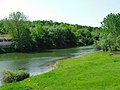
The Ogosta in Martinowo ...

... in Tschiprovzi.

The Dŭlgidelska Ogosta at Dalgi Del

... at Goweschda ...

... at Gavril Genovo ...

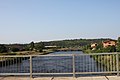
... the Ogosta reservoir near Montana ...
... the Ogosta shortly after leaving the Ogosta reservoir ...

the Ogosta near Vladimirovo ...
... at Hajredin ...

... between Gloschene and Mizia.


Web links
Individual evidence
- ↑ a b Tanya Vasileva, Peter Gerginov, Tatiana Orehova: Groundwater and Human Pressure in the Ogosta River Basin . Geological Institute, Bulgarian Academy of Sciences, Sofia, Bulgaria. May 31, 2008. Retrieved March 5, 2017.
- ^ John Bagnell Bury et al .: The Cambridge Ancient History: the Augustan Empire ; Cambridge University Press, 1934, reprinted 1952.
- ↑ Source https://latitude.to/articles-by-country/bg/bulgaria/197239/ogosta
- ↑ name = Yearbook> Statistical Yearbook 2017 , National Statistical Institute (Bulgaria) , p. 17
- ↑ География на България. Физическа и социално-икономическа география. Географски институт - БАН, ФорКом, ( Geography of Bulgaria. Physical and socio-economic geography. Publisher: Institute of Geography ) - BAS, Sofia, 2002, p. 200. ISBN 954-464-123-8
- ↑ Teodora Stoyanowa: "Ecological status of Ogosta" in "Acta Zoologica", 2014.
- ↑ Teodora Stoyanova, Ivan Traykov: Assessment of the Ecological Status of Ogosta River, Northwestern Bulgaria, based on the Macrozoobenthos and the General Physical and Chemical Quality element . In: Acta Zoologica Bulgarica . 2014. Retrieved March 5, 2017.
- ↑ Peter Gerginow et al: Arsenic pollution and speciation in the Ogosta River floodplain ("Arsenic pollution and effects in the flood zone of the Ogosta River"); June 2017
- ↑ Elke Süß: Arsenic uptake and specification in crops of contaminated sites using the example of the area around the Ogosta River (Bulgaria); German Research Foundation, Project No. 221913004; 2012 to 2015
- ↑ Iso Christel et al: Arsenic pollution of the Ogosta floodplains and their environmental influences; Geophysical Research Summaries Vol. 20, EGU2018-7052, ETH Zurich 2018ETH
- ↑ http://www.bgsever.info/br-41_2006/stranici/str-4.htm
- ↑ Ogosta Point: . Australian Government Department of Environment and Energy Antarctic Division. Retrieved March 5, 2017.