Ohe (Schunter)
|
Oh oh ditch |
||
|
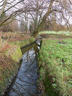
The Ohe on the outskirts of Rühme with a view downstream to the north. |
||
| Data | ||
| Water code | DE : 482893 | |
| location | Germany , Lower Saxony , Braunschweig | |
| River system | Weser | |
| Drain over | Schunter → Oker → Aller → Weser → North Sea | |
| source | Rain collector at the street Butterbusch, Schuntersiedlung 52 ° 17 ′ 50 ″ N , 10 ° 31 ′ 53 ″ E |
|
| Source height | 70 m | |
| muzzle | At Rühme in the Alte Schunter coordinates: 52 ° 18 '46 " N , 10 ° 31' 34" E 52 ° 18 '46 " N , 10 ° 31' 34" E |
|
| Mouth height | 69 m | |
| Height difference | 1 m | |
| Bottom slope | 0.42 ‰ | |
| length | 2.4 km | |
| Big cities | Braunschweig | |
| The GKZ is the Schunter between Mittelriede and Beberbach. | ||
|
Map of the Schunter Canal from 1761. At the top left of the map you can see the Dowesee and its outflow to the Schunter. |
||
The Ohe is an approximately 2.4 km long meadow stream in the northeast of Braunschweig , which flows into the Schunter at the federal motorway 2 and forms the western border of the Schunteraue landscape protection area.
geography
Today the Ohe rises in a rainwater retention basin of the Schuntersiedlung west of the street Butterberg and north of the street Ohefeld which crosses the river Aue . It flows out of the basin in a south-westerly direction and turns north-northwest into the presumably original drainage ditch of the Dowesees . After a slight swing to the west towards the Vorwerk settlement, it bends north in heavily straightened sections and runs through the meadows and pastures of the Schunteraue. At the level of the Flachsrottenweg it reaches the slightly higher settlement, branches out in the floodplain and flows through a pond with a side arm. Before the A2, it reaches the river bed of the Alte Schunter , which is passed under the motorway there.
Water quality
The water structure quality was investigated in 2010 by the Institute for Geoecology of the Technical University of Braunschweig on behalf of the city drainage system Braunschweig, where the brook was named Ohe Graben and mapped over a length of 2.344 km. The lower course of the brook in the Schunteraue is rated as largely "near-natural" and "moderately impaired", while the other sections with their straight lines and poorly structured, bare banks are classified as significantly lower or even "unfamiliar".
Web links
- Map of the Ohe at openstreetmap.org
Individual evidence
- ↑ a b c LGLN : Topographic map 1: 50,000 , status 2000, CD-ROM Top50-Viewer
- ↑ NLWKN : List of areas for the Lower Saxony Hydrographic Map , as of 2010, p. 73. FV_Weser.pdf, retrieved from Umwelt.niedersachsen.de on August 19, 2013.
- ^ City of Braunschweig: Ordinance for the protection of parts of the landscape in the city of Braunschweig. from March 25, 1968. Braunschweig December 19, 1983.
- ^ Institute for Geoecology, TU Braunschweig, Thomas Ols Eggers: Water structure and water quality investigations in flowing waters in the area of the city of Braunschweig, annual report 2010. Braunschweig 2010, p. 7 ff.

