Ohio State Route 163

|
|
|---|---|
| map | |

|
|
| Basic data | |
| Overall length: | 74.42 km |
| Opening: | 1923 |
| State: |
Ohio |
| Starting point: |
|
| End point: | Hartshorn Road at Marblehead |
| Counties: | Wood , Ottawa |
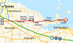
State Route 163 ( SR 163 ) is a 74.42 km long west-east running state highway in the northwest of the US state Ohio . The western terminus of SR 163 is at a T-like intersection with US Highway 20 (US 20) and US Highway 23 (US 23) about 10 km southeast of the city limits of Perrysburg . The road has its eastern end point at the intersection with Hartshorn Road, about 3 km west of Marblehead, on the peninsula between Lake Erie and Sandusky Bay .
Route description
The route of the SR 163 runs through the northeast of Wood County and the entire width of Ottawa County . No section of the route is part of the National Highway System (NHS), which is considered essential to the economy, mobility and defense of the United States.
history
The highway has been designated as SR 163 since 1923. Originally, the highway along its current route from the intersection with the SR 51 was part of the then SR 2 , which later became the SR 102, which is no longer in existence. It ran along the outskirts of Genoa to the east end at Marblehead. SR 163 was extended along a previously unnumbered route from Genoa westward into Wood County to today's western terminus on US 20 southeast of Perrysburg.
course
| county | City or Township | mi | km | direction | Remarks |
|---|---|---|---|---|---|
| Wood County | Troy township | 0.00 | 0.00 |
|
western end point at T-junction |
|
Troy - Lake - township boundary |
2.29 | 3.69 |
|
||
| Ottawa | Clay Township | 8.90 | 14.32 |
|
Traffic light intersection |
|
Harris - Benton - township boundary |
14.83 | 23.87 |
|
||
| Oak Harbor | 18.66 | 30.03 |
|
western end point of the common course of the SR 105 | |
| 19.10 | 30.74 |
|
eastern end of the common course with SR 105, at the same time eastern end point of SR 105 | ||
| Erie Township | 25.69 | 41.34 |
|
southern end point of the SR 358 | |
| 26.73 | 43.02 |
|
Exit 115 (SR 2); Entrance to SR 2 eastwards and exit from SR 2 westwards | ||
| Port Clinton | 31.92 | 51.37 |
|
Exit 121 (SR 2) | |
| Danbury Township | 35.58 | 57.26 |
|
||
| 36.19 | 58.24 |
|
western end of the common course with SR 269 | ||
| 36.62 | 58.93 |
|
eastern end of the common course with SR 269 | ||
| 46.28 | 74.48 | Hartshorn Road | |||
|
1,000 mi = 1,609 km; 1,000 km = 0.621 mi End point of common course entry / exit not in both directions
|
|||||
See also
supporting documents
- ^ A b Ohio Department of Transportation : Technical Services Straight Line Diagrams: SR 163, Wood County . Archived from the original on March 25, 2012. Info: The archive link was automatically inserted and not yet checked. Please check the original and archive link according to the instructions and then remove this notice. Retrieved June 18, 2011.
- ^ A b Ohio Department of Transportation: Technical Services Straight Line Diagrams: SR 163, Ottawa County . Archived from the original on March 25, 2012. Info: The archive link was automatically inserted and not yet checked. Please check the original and archive link according to the instructions and then remove this notice. Retrieved June 18, 2011.
- ^ Federal Highway Administration . National Highway System: Ohio [map] (PDF). Retrieved June 20, 2011.
- ^ A b Ohio Department of Highways and Public Works (April 1922). [ Map of Ohio State Highways ( Memento from December 28, 2010 in the Internet Archive ) Map of Ohio State Highways] [Map] ( MrSID ). Cartography by ODHPW. Retrieved August 26, 2011.
- ^ A b Ohio Department of Highways and Public Works (July 1923). [ Map of Ohio Showing State Routes ( Memento from December 28, 2010 in the Internet Archive ) Map of Ohio Showing State Routes] [Map] (MrSID). Cartography by ODHPW. Retrieved August 26, 2011.
- ^ Ohio Department of Highways (1934). [ Map of Ohio Showing State Highway System ( Memento from December 28, 2010 in the Internet Archive ) Map of Ohio Showing State Highway System] [Map] (MrSID). Cartography of ODOH. Retrieved August 26, 2011.
- ^ Ohio Department of Highways (1935). [ Official Ohio Highway Map ( Memento of December 28, 2010 on the Internet Archive ) Official Ohio Highway Map] [Map] (MrSID). Cartography of ODOH. Retrieved August 26, 2011.